Cetate geodata
Cetate (Dolj) is a seat of a second-order administrative division; located in Romania in Europe/Bucharest (GMT+3) time zone. With population of 5,908 people, there are 559 cities with bigger population in this country. Compared to other cities in Romania, 95.5% of cities are located further ↑North; 83.8% of cities are located further →East and 93.5% of cities have higher elevation than Cetate. Note1


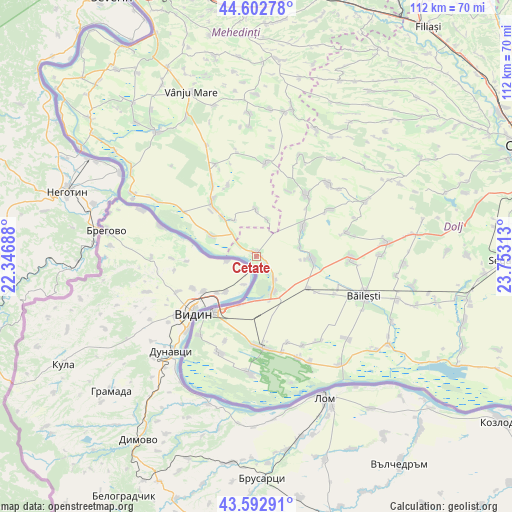
Cetate GPS coordinates[2]
44° 6' 0" North, 23° 3' 0" East
| Map corner | latitude | longitude |
|---|---|---|
| Upper-left | 44.60278°, | 22.34688° |
| Center: | 44.1°, | 23.05° |
| Lower-right: | 43.59291°, | 23.75313° |
| Map W x H: | 112.3×112.3 km | = 69.8×69.8mi |
| max Lat: | 48.23793° ⇑95.5% North |
| Cetate: | 44.1° |
| min Lat: | ⇓4.5% South 43.65638° |
| min Long | Cetate | max Long |
| 20.31667° | 23.05° | 29.65403° |
| W 16.2%⇐ | ⇒83.8% E |
Elevation
Elevation of Cetate is 41 m = 135 ft, and this is 213.9 m = 702 ft below average elevation for this country.
| Max E: |
1278 m = 4193 ft | 93.5% |
| Avg. | 254.9 m = 836 ft | |
| Cetate | 41 m = 135 ft | |
Min E: |
-2 m = -7 ft | 6.5% |
See also: Romania elevation on elevation.city.
Geographical zone
Cetate is located in North temperate zone (between Tropic of Cancer and the Arctic Circle). Distance of this Northern Tropic circle is 2297.5 km =1427.6 mi to South.| Distance of | km | miles | from Cetate |
|---|---|---|---|
| North Pole | 5103.6 | 3171.2 | to North |
| Arctic Circle | 2497.7 | 1552 | to North |
| Tropic Cancer | 2297.5 | 1427.6 | to South |
| Equator | 4903.5 | 3046.9 | to South |


Nearby cities:
15 places around Cetate: (largest is in red/bold)
• Aurora
13.6 km =8.5 mi,  319°
319°
• Basarabi
11 km =6.8 mi,  197°
197°
• Dobridor
9.8 km =6.1 mi,  77°
77°
• Dârvari
11.1 km =6.9 mi,  0°
0°
• Gemeni
8.5 km =5.3 mi,  17°
17°
• Golenți
9.7 km =6 mi,  176°
176°
• Hunia
6.3 km =3.9 mi,  141°
141°
• Izimșa
11.5 km =7.1 mi, 319°
• Maglavit
8.4 km =5.2 mi,  151°
151°
• Moreni
2.6 km =1.6 mi,  122°
122°
• Moţăţei
12.1 km =7.5 mi,  98°
98°
• Moțăței Gară
13.3 km =8.3 mi, 120°
• Obârșia de Câmp
9.8 km =6.1 mi,  325°
325°
• Salcia
10.8 km =6.7 mi,  294°
294°
• Unirea
12 km =7.5 mi,  62°
62°
Sources, notices
• [Note1] Compared only with cities in Romania existing in our database
• [Src1] Map data: © OpenStreetMap contributors (CC-BY-SA)
• [Src2] Other city data from geonames.org with taken over terms of usage.
• [Src3] Geographical zone / Annual Mean Temperature by Robert A. Rohde @ Wikipedia
