Cernavodă geodata
Cernavodă (Constanța) is a seat of a second-order administrative division; located in Romania in Europe/Bucharest (GMT+3) time zone. With population of 18,502 people, there are 112 cities with bigger population in this country. Compared to other cities in Romania, 89.9% of cities are located further ↑North; 96.5% of cities are located further ←West and 98.4% of cities have higher elevation than Cernavodă. Note1


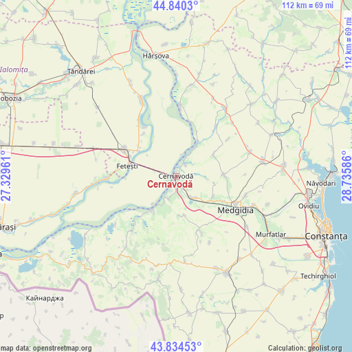
Cernavodă GPS coordinates[2]
44° 20' 22.452" North, 28° 1' 57.828" East
| Map corner | latitude | longitude |
|---|---|---|
| Upper-left | 44.8403°, | 27.32961° |
| Center: | 44.33957°, | 28.03273° |
| Lower-right: | 43.83453°, | 28.73586° |
| Map W x H: | 111.8×111.8 km | = 69.5×69.5mi |
| max Lat: | 48.23793° ⇑89.9% North |
| Cernavodă: | 44.33957° |
| min Lat: | ⇓10.1% South 43.65638° |
| min Long | Cernavodă | max Long |
| 20.31667° | 28.03273° | 29.65403° |
| W 96.5%⇐ | ⇒3.5% E |
Elevation
Elevation of Cernavodă is 15 m = 49 ft, and this is 239.9 m = 787 ft below average elevation for this country.
| Max E: |
1278 m = 4193 ft | 98.4% |
| Avg. | 254.9 m = 836 ft | |
| Cernavodă | 15 m = 49 ft | |
Min E: |
-2 m = -7 ft | 1.6% |
See also: Romania elevation on elevation.city.
Geographical zone
Cernavodă is located in North temperate zone (between Tropic of Cancer and the Arctic Circle). Distance of this Northern Tropic circle is 2324.2 km =1444.2 mi to South.| Distance of | km | miles | from Cernavodă |
|---|---|---|---|
| North Pole | 5077 | 3154.7 | to North |
| Arctic Circle | 2471.1 | 1535.5 | to North |
| Tropic Cancer | 2324.2 | 1444.2 | to South |
| Equator | 4930.1 | 3063.4 | to South |


Nearby cities:
15 places around Cernavodă: (largest is in red/bold)
• Dunărea
12.8 km =8 mi,  31°
31°
• Feteşti
16.6 km =10.3 mi,  287°
287°
• Făclia
8.8 km =5.5 mi,  138°
138°
• Ivrinezu Mare
12.5 km =7.8 mi,  167°
167°
• Mircea Vodă
12.4 km =7.7 mi,  120°
120°
• Rasova
13 km =8.1 mi,  216°
216°
• Saligny
8 km =5 mi, 144°
• Satu Nou
17.2 km =10.7 mi, 116°
• Seimeni
5.6 km =3.5 mi, 29°
• Seimenii Mici
4.6 km =2.9 mi,  39°
39°
• Siliştea
12.6 km =7.8 mi,  57°
57°
• Stelnica
14.6 km =9.1 mi,  305°
305°
• Tortoman
14.7 km =9.1 mi,  85°
85°
• Vlașca
15.9 km =9.9 mi, 293°
• Ştefan cel Mare
5.5 km =3.4 mi, 140°
Sources, notices
• [Note1] Compared only with cities in Romania existing in our database
• [Src1] Map data: © OpenStreetMap contributors (CC-BY-SA)
• [Src2] Other city data from geonames.org with taken over terms of usage.
• [Src3] Geographical zone / Annual Mean Temperature by Robert A. Rohde @ Wikipedia
