Cernat geodata
Cernat (Covasna) is a seat of a second-order administrative division; located in Romania in Europe/Bucharest (GMT+3) time zone. With population of 3,963 people, there are 1177 cities with bigger population in this country. Compared to other cities in Romania, 54% of cities are located further ↓South; 63.6% of cities are located further ←West and 92.7% of cities have lower elevation than Cernat. Note1


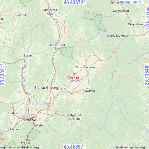
Cernat GPS coordinates[2]
45° 57' 0" North, 26° 1' 59.988" East
| Map corner | latitude | longitude |
|---|---|---|
| Upper-left | 46.43672°, | 25.33021° |
| Center: | 45.95°, | 26.03333° |
| Lower-right: | 45.45897°, | 26.73646° |
| Map W x H: | 108.7×108.7 km | = 67.5×67.5mi |
| max Lat: | 48.23793° ⇑46% North |
| Cernat: | 45.95° |
| min Lat: | ⇓54% South 43.65638° |
| min Long | Cernat | max Long |
| 20.31667° | 26.03333° | 29.65403° |
| W 63.6%⇐ | ⇒36.4% E |
Elevation
Elevation of Cernat is 563 m = 1847 ft, and this is 308.1 m = 1011 ft above average elevation for this country.
| Max E: |
1278 m = 4193 ft | 7.3% |
| Cernat | 563 m 1847 ft | |
| Avg. | 254.9 m = 836 ft | |
Min E: |
-2 m = -7 ft | 92.7% |
See also: Romania elevation on elevation.city.
Geographical zone
Cernat is located in North temperate zone (between Tropic of Cancer and the Arctic Circle). Distance of this North polar circle is 2292 km =1424.2 mi to North.| Distance of | km | miles | from Cernat |
|---|---|---|---|
| North Pole | 4897.9 | 3043.4 | to North |
| Arctic Circle | 2292 | 1424.2 | to North |
| Tropic Cancer | 2503.2 | 1555.4 | to South |
| Equator | 5109.2 | 3174.7 | to South |


Nearby cities:
15 places around Cernat: (largest is in red/bold)
• Brateş
13.2 km =8.2 mi,  168°
168°
• Catalina
9.2 km =5.7 mi,  78°
78°
• Dalnic
4.7 km =2.9 mi,  229°
229°
• Moacşa
10.6 km =6.6 mi,  209°
209°
• Mărcușa
4.2 km =2.6 mi,  153°
153°
• Mărtineni
5.8 km =3.6 mi,  123°
123°
• Petriceni
13.8 km =8.6 mi,  17°
17°
• Reci
13.5 km =8.4 mi, 214°
• Surcea
8.5 km =5.3 mi, 153°
• Sânzieni
13.5 km =8.4 mi,  34°
34°
• Tamașfalău
9.7 km =6 mi,  138°
138°
• Telechia
10.1 km =6.3 mi, 174°
• Turia
9.4 km =5.8 mi,  7°
7°
• Târgu Secuiesc
9.5 km =5.9 mi,  54°
54°
• Zăbala
12.9 km =8 mi, 115°
Sources, notices
• [Note1] Compared only with cities in Romania existing in our database
• [Src1] Map data: © OpenStreetMap contributors (CC-BY-SA)
• [Src2] Other city data from geonames.org with taken over terms of usage.
• [Src3] Geographical zone / Annual Mean Temperature by Robert A. Rohde @ Wikipedia
