Camăr geodata
Camăr (Sălaj) is a seat of a second-order administrative division; located in Romania in Europe/Bucharest (GMT+3) time zone. With population of 1,855 people, there are 2755 cities with bigger population in this country. Compared to other cities in Romania, 86.5% of cities are located further ↓South; 88.9% of cities are located further →East and 57.1% of cities have higher elevation than Camăr. Note1


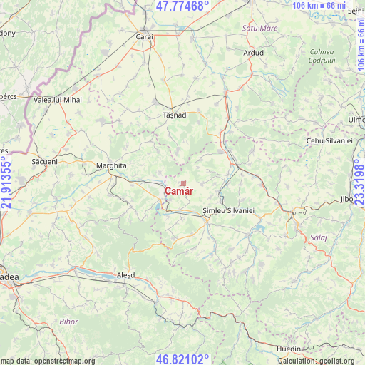
Camăr GPS coordinates[2]
47° 18' 0" North, 22° 37' 0.012" East
| Map corner | latitude | longitude |
|---|---|---|
| Upper-left | 47.77468°, | 21.91355° |
| Center: | 47.3°, | 22.61667° |
| Lower-right: | 46.82102°, | 23.3198° |
| Map W x H: | 106×106 km | = 65.9×65.9mi |
| max Lat: | 48.23793° ⇑13.5% North |
| Camăr: | 47.3° |
| min Lat: | ⇓86.5% South 43.65638° |
| min Long | Camăr | max Long |
| 20.31667° | 22.61667° | 29.65403° |
| W 11.1%⇐ | ⇒88.9% E |
Elevation
Elevation of Camăr is 178 m = 584 ft, and this is 76.9 m = 252 ft below average elevation for this country.
| Max E: |
1278 m = 4193 ft | 57.1% |
| Avg. | 254.9 m = 836 ft | |
| Camăr | 178 m = 584 ft | |
Min E: |
-2 m = -7 ft | 42.9% |
See also: Romania elevation on elevation.city.
Geographical zone
Camăr is located in North temperate zone (between Tropic of Cancer and the Arctic Circle). Distance of this North polar circle is 2141.9 km =1330.9 mi to North.| Distance of | km | miles | from Camăr |
|---|---|---|---|
| North Pole | 4747.8 | 2950.1 | to North |
| Arctic Circle | 2141.9 | 1330.9 | to North |
| Tropic Cancer | 2653.3 | 1648.7 | to South |
| Equator | 5259.3 | 3268 | to South |


Nearby cities:
15 places around Camăr: (largest is in red/bold)
• Almașu Mare
7.1 km =4.4 mi,  296°
296°
• Almașu Mic
8.2 km =5.1 mi,  283°
283°
• Balc
6.6 km =4.1 mi,  253°
253°
• Carastelec
6.3 km =3.9 mi,  90°
90°
• Cehal
9.4 km =5.8 mi,  352°
352°
• Criștelec
9 km =5.6 mi,  116°
116°
• Foglaş
8.4 km =5.2 mi,  228°
228°
• Ip
7.8 km =4.8 mi,  161°
161°
• Marca
10 km =6.2 mi,  202°
202°
• Pusta
10.1 km =6.3 mi,  126°
126°
• Suplacu de Barcău
8 km =5 mi, 233°
• Uileacu Șimleului
10.6 km =6.6 mi,  102°
102°
• Zalnoc
9.2 km =5.7 mi,  35°
35°
• Zăuan
9.1 km =5.7 mi, 157°
• Șumal
4.4 km =2.7 mi,  240°
240°
Sources, notices
• [Note1] Compared only with cities in Romania existing in our database
• [Src1] Map data: © OpenStreetMap contributors (CC-BY-SA)
• [Src2] Other city data from geonames.org with taken over terms of usage.
• [Src3] Geographical zone / Annual Mean Temperature by Robert A. Rohde @ Wikipedia
