Beidaud geodata
Beidaud (Tulcea) is a seat of a second-order administrative division; located in Romania in Europe/Bucharest (GMT+3) time zone. With population of 1,793 people, there are 2829 cities with bigger population in this country. Compared to other cities in Romania, 79.7% of cities are located further ↑North; 98.9% of cities are located further ←West and 79.9% of cities have higher elevation than Beidaud. Note1


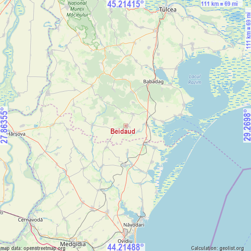
Beidaud GPS coordinates[2]
44° 43' 0.012" North, 28° 34' 0.012" East
| Map corner | latitude | longitude |
|---|---|---|
| Upper-left | 45.21415°, | 27.86355° |
| Center: | 44.71667°, | 28.56667° |
| Lower-right: | 44.21488°, | 29.2698° |
| Map W x H: | 111.1×111.1 km | = 69×69mi |
| max Lat: | 48.23793° ⇑79.7% North |
| Beidaud: | 44.71667° |
| min Lat: | ⇓20.3% South 43.65638° |
| min Long | Beidaud | max Long |
| 20.31667° | 28.56667° | 29.65403° |
| W 98.9%⇐ | ⇒1.1% E |
Elevation
Elevation of Beidaud is 95 m = 312 ft, and this is 159.9 m = 525 ft below average elevation for this country.
| Max E: |
1278 m = 4193 ft | 79.9% |
| Avg. | 254.9 m = 836 ft | |
| Beidaud | 95 m = 312 ft | |
Min E: |
-2 m = -7 ft | 20.1% |
See also: Romania elevation on elevation.city.
Geographical zone
Beidaud is located in North temperate zone (between Tropic of Cancer and the Arctic Circle). Distance of this Northern Tropic circle is 2366.1 km =1470.2 mi to South.| Distance of | km | miles | from Beidaud |
|---|---|---|---|
| North Pole | 5035 | 3128.6 | to North |
| Arctic Circle | 2429.1 | 1509.4 | to North |
| Tropic Cancer | 2366.1 | 1470.2 | to South |
| Equator | 4972 | 3089.5 | to South |


Nearby cities:
15 places around Beidaud: (largest is in red/bold)
• Baia
7.9 km =4.9 mi,  90°
90°
• Camena
10.9 km =6.8 mi,  17°
17°
• Casimcea
15.9 km =9.9 mi,  276°
276°
• Ceamurlia de Jos
12 km =7.5 mi,  81°
81°
• Ceamurlia de Sus
6.2 km =3.9 mi,  32°
32°
• Fântânele
11.6 km =7.2 mi,  176°
176°
• Lunca
16.6 km =10.3 mi, 83°
• Mihai Viteazu
13.1 km =8.1 mi,  135°
135°
• Neatârnarea
5.7 km =3.5 mi,  304°
304°
• Râmnicu de Jos
13.1 km =8.1 mi,  222°
222°
• Războieni
12.8 km =8 mi,  294°
294°
• Sarighiol de Deal
4.6 km =2.9 mi,  245°
245°
• Slava Rusă
15.2 km =9.4 mi,  11°
11°
• Stejaru
5.7 km =3.5 mi,  346°
346°
• Vasile Alecsandri
10 km =6.2 mi,  331°
331°
Sources, notices
• [Note1] Compared only with cities in Romania existing in our database
• [Src1] Map data: © OpenStreetMap contributors (CC-BY-SA)
• [Src2] Other city data from geonames.org with taken over terms of usage.
• [Src3] Geographical zone / Annual Mean Temperature by Robert A. Rohde @ Wikipedia
