Bălţăteşti geodata
Bălţăteşti (Neamţ) is a seat of a second-order administrative division; located in Romania in Europe/Bucharest (GMT+3) time zone. With population of 6,635 people, there are 451 cities with bigger population in this country. Compared to other cities in Romania, 81.7% of cities are located further ↓South; 68.8% of cities are located further ←West and 88.6% of cities have lower elevation than Bălţăteşti. Note1


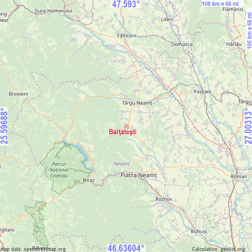
Bălţăteşti GPS coordinates[2]
47° 7' 0.012" North, 26° 18' 0" East
| Map corner | latitude | longitude |
|---|---|---|
| Upper-left | 47.593°, | 25.59688° |
| Center: | 47.11667°, | 26.3° |
| Lower-right: | 46.63604°, | 27.00313° |
| Map W x H: | 106.4×106.4 km | = 66.1×66.1mi |
| max Lat: | 48.23793° ⇑18.3% North |
| Bălţăteşti: | 47.11667° |
| min Lat: | ⇓81.7% South 43.65638° |
| min Long | Bălţăteşti | max Long |
| 20.31667° | 26.3° | 29.65403° |
| W 68.8%⇐ | ⇒31.2% E |
Elevation
Elevation of Bălţăteşti is 491 m = 1611 ft, and this is 236.1 m = 775 ft above average elevation for this country.
| Max E: |
1278 m = 4193 ft | 11.4% |
| Bălţăteşti | 491 m 1611 ft | |
| Avg. | 254.9 m = 836 ft | |
Min E: |
-2 m = -7 ft | 88.6% |
See also: Romania elevation on elevation.city.
Geographical zone
Bălţăteşti is located in North temperate zone (between Tropic of Cancer and the Arctic Circle). Distance of this North polar circle is 2162.3 km =1343.6 mi to North.| Distance of | km | miles | from Bălţăteşti |
|---|---|---|---|
| North Pole | 4768.2 | 2962.8 | to North |
| Arctic Circle | 2162.3 | 1343.6 | to North |
| Tropic Cancer | 2633 | 1636.1 | to South |
| Equator | 5238.9 | 3255.3 | to South |


Nearby cities:
15 places around Bălţăteşti: (largest is in red/bold)
• Agapia
5.7 km =3.5 mi,  347°
347°
• Cracăul Negru
5.2 km =3.2 mi,  240°
240°
• Crăcăoani
2.2 km =1.4 mi,  157°
157°
• Curechiștea
8.9 km =5.5 mi,  77°
77°
• Filioara
5.1 km =3.2 mi,  342°
342°
• Ghindăoani
3.1 km =1.9 mi,  104°
104°
• Grumăzeşti
5.4 km =3.4 mi,  69°
69°
• Magazia
3.3 km =2.1 mi, 242°
• Poiana Crăcăoani
5.7 km =3.5 mi,  167°
167°
• Săcălușești
6.7 km =4.2 mi,  27°
27°
• Topolița
8.5 km =5.3 mi,  47°
47°
• Valea Arini
1.2 km =0.7 mi, 337°
• Valea Seacă
2.5 km =1.6 mi,  359°
359°
• Varatec
3.5 km =2.2 mi,  329°
329°
• Vânători-Neamţ
9.4 km =5.8 mi,  7°
7°
Sources, notices
• [Note1] Compared only with cities in Romania existing in our database
• [Src1] Map data: © OpenStreetMap contributors (CC-BY-SA)
• [Src2] Other city data from geonames.org with taken over terms of usage.
• [Src3] Geographical zone / Annual Mean Temperature by Robert A. Rohde @ Wikipedia
