Avrig geodata
Avrig (Sibiu) is a seat of a second-order administrative division; located in Romania in Europe/Bucharest (GMT+3) time zone. With population of 14,032 people, there are 137 cities with bigger population in this country. Compared to other cities in Romania, 51.7% of cities are located further ↑North; 62.1% of cities are located further →East and 79.2% of cities have lower elevation than Avrig. Note1


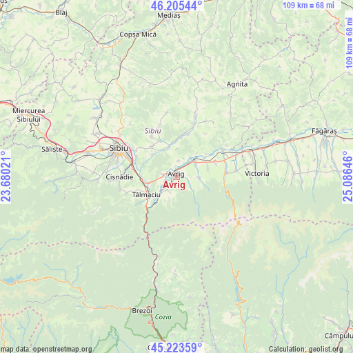
Avrig GPS coordinates[2]
45° 43' 0.012" North, 24° 22' 59.988" East
| Map corner | latitude | longitude |
|---|---|---|
| Upper-left | 46.20544°, | 23.68021° |
| Center: | 45.71667°, | 24.38333° |
| Lower-right: | 45.22359°, | 25.08646° |
| Map W x H: | 109.2×109.2 km | = 67.9×67.9mi |
| max Lat: | 48.23793° ⇑51.7% North |
| Avrig: | 45.71667° |
| min Lat: | ⇓48.3% South 43.65638° |
| min Long | Avrig | max Long |
| 20.31667° | 24.38333° | 29.65403° |
| W 37.9%⇐ | ⇒62.1% E |
Elevation
Elevation of Avrig is 385 m = 1263 ft, and this is 130.1 m = 427 ft above average elevation for this country.
| Max E: |
1278 m = 4193 ft | 20.8% |
| Avrig | 385 m 1263 ft | |
| Avg. | 254.9 m = 836 ft | |
Min E: |
-2 m = -7 ft | 79.2% |
See also: Romania elevation on elevation.city.
Geographical zone
Avrig is located in North temperate zone (between Tropic of Cancer and the Arctic Circle). Distance of this North polar circle is 2318 km =1440.3 mi to North.| Distance of | km | miles | from Avrig |
|---|---|---|---|
| North Pole | 4923.8 | 3059.5 | to North |
| Arctic Circle | 2318 | 1440.3 | to North |
| Tropic Cancer | 2477.3 | 1539.3 | to South |
| Equator | 5083.2 | 3158.6 | to South |


Nearby cities:
15 places around Avrig: (largest is in red/bold)
• Bradu
4 km =2.5 mi,  278°
278°
• Cașolț
10.4 km =6.5 mi,  311°
311°
• Daia
12.1 km =7.5 mi,  321°
321°
• Mârșa
2.1 km =1.3 mi,  208°
208°
• Porumbacu de Jos
6.4 km =4 mi,  54°
54°
• Porumbacu de Sus
6.9 km =4.3 mi,  91°
91°
• Racoviţa
4.5 km =2.8 mi, 214°
• Roşia
12.3 km =7.6 mi,  335°
335°
• Scoreiu
12.5 km =7.8 mi,  67°
67°
• Sebeșu de Jos
8.2 km =5.1 mi, 206°
• Sebeșu de Sus
7.4 km =4.6 mi,  197°
197°
• Săcădate
4.9 km =3 mi,  6°
6°
• Turnu Roşu
11.3 km =7 mi, 214°
• Tălmaciu
10.7 km =6.6 mi,  239°
239°
• Veștem
11.2 km =7 mi,  270°
270°
Sources, notices
• [Note1] Compared only with cities in Romania existing in our database
• [Src1] Map data: © OpenStreetMap contributors (CC-BY-SA)
• [Src2] Other city data from geonames.org with taken over terms of usage.
• [Src3] Geographical zone / Annual Mean Temperature by Robert A. Rohde @ Wikipedia
