Agârbiciu geodata
Agârbiciu (Cluj) is a populated place; located in Romania in Europe/Bucharest (GMT+3) time zone. With population of 564 people, there are 6472 cities with bigger population in this country. Compared to other cities in Romania, 73.5% of cities are located further ↓South; 80.4% of cities are located further →East and 91.7% of cities have lower elevation than Agârbiciu. Note1


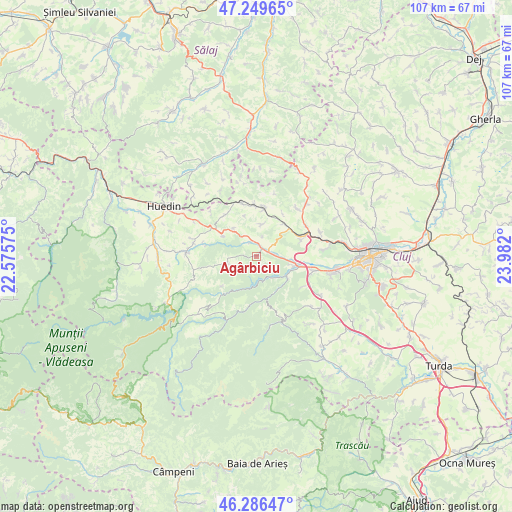
Agârbiciu GPS coordinates[2]
46° 46' 12.756" North, 23° 16' 43.932" East
| Map corner | latitude | longitude |
|---|---|---|
| Upper-left | 47.24965°, | 22.57575° |
| Center: | 46.77021°, | 23.27887° |
| Lower-right: | 46.28647°, | 23.982° |
| Map W x H: | 107.1×107.1 km | = 66.5×66.5mi |
| max Lat: | 48.23793° ⇑26.5% North |
| Agârbiciu: | 46.77021° |
| min Lat: | ⇓73.5% South 43.65638° |
| min Long | Agârbiciu | max Long |
| 20.31667° | 23.27887° | 29.65403° |
| W 19.6%⇐ | ⇒80.4% E |
Elevation
Elevation of Agârbiciu is 544 m = 1785 ft, and this is 289.1 m = 948 ft above average elevation for this country.
| Max E: |
1278 m = 4193 ft | 8.3% |
| Agârbiciu | 544 m 1785 ft | |
| Avg. | 254.9 m = 836 ft | |
Min E: |
-2 m = -7 ft | 91.7% |
See also: Romania elevation on elevation.city.
Geographical zone
Agârbiciu is located in North temperate zone (between Tropic of Cancer and the Arctic Circle). Distance of this North polar circle is 2200.8 km =1367.5 mi to North.| Distance of | km | miles | from Agârbiciu |
|---|---|---|---|
| North Pole | 4806.7 | 2986.7 | to North |
| Arctic Circle | 2200.8 | 1367.5 | to North |
| Tropic Cancer | 2594.4 | 1612.1 | to South |
| Equator | 5200.4 | 3231.4 | to South |


Nearby cities:
15 places around Agârbiciu: (largest is in red/bold)
• Aghireșu
11.8 km =7.3 mi,  344°
344°
• Aghireșu-Fabrici
10.8 km =6.7 mi,  356°
356°
• Bedeciu
11.5 km =7.1 mi,  283°
283°
• Căpuşu Mare
2.2 km =1.4 mi,  47°
47°
• Căpușu Mic
3.5 km =2.2 mi,  328°
328°
• Gilău
7.6 km =4.7 mi,  123°
123°
• Gârbău
9 km =5.6 mi,  38°
38°
• Leghia
10.9 km =6.8 mi,  321°
321°
• Luna de Sus
12.3 km =7.6 mi,  104°
104°
• Macău
6.8 km =4.2 mi,  9°
9°
• Râșca
13.6 km =8.5 mi,  255°
255°
• Someșu Cald
5.7 km =3.5 mi,  136°
136°
• Turea
10.6 km =6.6 mi,  32°
32°
• Viștea
10.1 km =6.3 mi,  69°
69°
• Șardu
13.3 km =8.3 mi, 40°
Sources, notices
• [Note1] Compared only with cities in Romania existing in our database
• [Src1] Map data: © OpenStreetMap contributors (CC-BY-SA)
• [Src2] Other city data from geonames.org with taken over terms of usage.
• [Src3] Geographical zone / Annual Mean Temperature by Robert A. Rohde @ Wikipedia
