Aghireș geodata
Aghireș (Sălaj) is a populated place; located in Romania in Europe/Bucharest (GMT+3) time zone. With population of 1,196 people, there are 3754 cities with bigger population in this country. Compared to other cities in Romania, 82.8% of cities are located further ↓South; 84.1% of cities are located further →East and 61.7% of cities have lower elevation than Aghireș. Note1


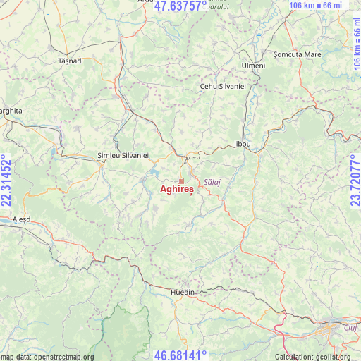
Aghireș GPS coordinates[2]
47° 9' 41.904" North, 23° 1' 3.504" East
| Map corner | latitude | longitude |
|---|---|---|
| Upper-left | 47.63757°, | 22.31452° |
| Center: | 47.16164°, | 23.01764° |
| Lower-right: | 46.68141°, | 23.72077° |
| Map W x H: | 106.3×106.3 km | = 66.1×66.1mi |
| max Lat: | 48.23793° ⇑17.2% North |
| Aghireș: | 47.16164° |
| min Lat: | ⇓82.8% South 43.65638° |
| min Long | Aghireș | max Long |
| 20.31667° | 23.01764° | 29.65403° |
| W 15.9%⇐ | ⇒84.1% E |
Elevation
Elevation of Aghireș is 273 m = 896 ft, and this is 18.1 m = 59 ft above average elevation for this country.
| Max E: |
1278 m = 4193 ft | 38.3% |
| Aghireș | 273 m 896 ft | |
| Avg. | 254.9 m = 836 ft | |
Min E: |
-2 m = -7 ft | 61.7% |
See also: Romania elevation on elevation.city.
Geographical zone
Aghireș is located in North temperate zone (between Tropic of Cancer and the Arctic Circle). Distance of this North polar circle is 2157.3 km =1340.5 mi to North.| Distance of | km | miles | from Aghireș |
|---|---|---|---|
| North Pole | 4763.2 | 2959.7 | to North |
| Arctic Circle | 2157.3 | 1340.5 | to North |
| Tropic Cancer | 2638 | 1639.2 | to South |
| Equator | 5243.9 | 3258.4 | to South |


Nearby cities:
15 places around Aghireș: (largest is in red/bold)
• Badon
10.3 km =6.4 mi,  343°
343°
• Crasna
8.9 km =5.5 mi,  273°
273°
• Crişeni
8.3 km =5.2 mi,  17°
17°
• Hereclean
9.8 km =6.1 mi,  359°
359°
• Horoatu Crasnei
10.6 km =6.6 mi,  252°
252°
• Meseşenii de Jos
2.9 km =1.8 mi,  243°
243°
• Meseșenii de Sus
4.6 km =2.9 mi,  212°
212°
• Mirşid
11.8 km =7.3 mi,  47°
47°
• Moigrad-Porolissum
10.3 km =6.4 mi,  67°
67°
• Panic
5.2 km =3.2 mi, 339°
• Recea
6.6 km =4.1 mi,  305°
305°
• Stârciu
11.1 km =6.9 mi,  221°
221°
• Treznea
10.2 km =6.3 mi,  132°
132°
• Vârşolţ
7.7 km =4.8 mi,  303°
303°
• Zalău
4.9 km =3 mi,  29°
29°
Sources, notices
• [Note1] Compared only with cities in Romania existing in our database
• [Src1] Map data: © OpenStreetMap contributors (CC-BY-SA)
• [Src2] Other city data from geonames.org with taken over terms of usage.
• [Src3] Geographical zone / Annual Mean Temperature by Robert A. Rohde @ Wikipedia
