Adâncata geodata
Adâncata (Suceava) is a seat of a second-order administrative division; located in Romania in Europe/Bucharest (GMT+3) time zone. With population of 7,779 people, there are 331 cities with bigger population in this country. Compared to other cities in Romania, 95.4% of cities are located further ↓South; 68.8% of cities are located further ←West and 80.8% of cities have lower elevation than Adâncata. Note1


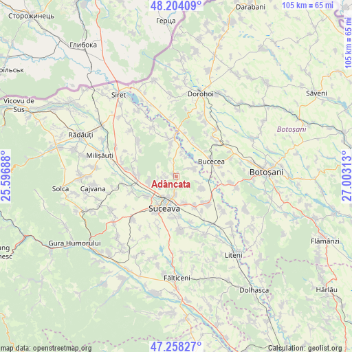
Adâncata GPS coordinates[2]
47° 43' 59.988" North, 26° 18' 0" East
| Map corner | latitude | longitude |
|---|---|---|
| Upper-left | 48.20409°, | 25.59688° |
| Center: | 47.73333°, | 26.3° |
| Lower-right: | 47.25827°, | 27.00313° |
| Map W x H: | 105.2×105.2 km | = 65.4×65.4mi |
| max Lat: | 48.23793° ⇑4.6% North |
| Adâncata: | 47.73333° |
| min Lat: | ⇓95.4% South 43.65638° |
| min Long | Adâncata | max Long |
| 20.31667° | 26.3° | 29.65403° |
| W 68.8%⇐ | ⇒31.2% E |
Elevation
Elevation of Adâncata is 401 m = 1316 ft, and this is 146.1 m = 479 ft above average elevation for this country.
| Max E: |
1278 m = 4193 ft | 19.2% |
| Adâncata | 401 m 1316 ft | |
| Avg. | 254.9 m = 836 ft | |
Min E: |
-2 m = -7 ft | 80.8% |
See also: Romania elevation on elevation.city.
Geographical zone
Adâncata is located in North temperate zone (between Tropic of Cancer and the Arctic Circle). Distance of this North polar circle is 2093.7 km =1301 mi to North.| Distance of | km | miles | from Adâncata |
|---|---|---|---|
| North Pole | 4699.6 | 2920.2 | to North |
| Arctic Circle | 2093.7 | 1301 | to North |
| Tropic Cancer | 2701.5 | 1678.6 | to South |
| Equator | 5307.4 | 3297.9 | to South |


Nearby cities:
15 places around Adâncata: (largest is in red/bold)
• Berești
6.1 km =3.8 mi,  25°
25°
• Călugăreni
3.5 km =2.2 mi,  346°
346°
• Fetești
4.2 km =2.6 mi,  132°
132°
• Hănțești
6 km =3.7 mi,  66°
66°
• Lipoveni
5.7 km =3.5 mi,  259°
259°
• Mitocași
2.8 km =1.7 mi,  266°
266°
• Mitocu Dragomirnei
3.7 km =2.3 mi, 270°
• Plopeni
8.8 km =5.5 mi,  160°
160°
• Poiana
7.2 km =4.5 mi, 345°
• Pătrăuţi
7.7 km =4.8 mi, 256°
• Siminicea
8.3 km =5.2 mi,  116°
116°
• Slobozia
6.9 km =4.3 mi,  13°
13°
• Stânca
10 km =6.2 mi, 347°
• Sălăgeni
9.3 km =5.8 mi, 132°
• Șerbănești
8.7 km =5.4 mi, 9°
Sources, notices
• [Note1] Compared only with cities in Romania existing in our database
• [Src1] Map data: © OpenStreetMap contributors (CC-BY-SA)
• [Src2] Other city data from geonames.org with taken over terms of usage.
• [Src3] Geographical zone / Annual Mean Temperature by Robert A. Rohde @ Wikipedia
