Vol’no-Nadezhdinskoye geodata
Vol’no-Nadezhdinskoye (Primorskiy (Maritime) Kray) is a populated place; located in Russia in Asia/Vladivostok (GMT+10) time zone. With population of 6,577 people, there are 2107 cities with bigger population in this country. Compared to other cities in Russia, 94.8% of cities are located further ↑North; 95.2% of cities are located further ←West and 85.1% of cities have higher elevation than Vol’no-Nadezhdinskoye. Note1


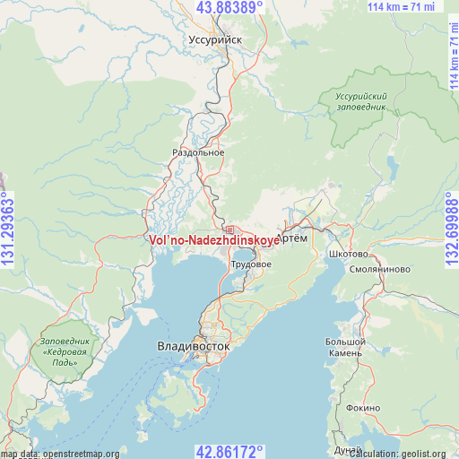
Vol’no-Nadezhdinskoye GPS coordinates[2]
43° 22' 29.856" North, 131° 59' 48.3" East
| Map corner | latitude | longitude |
|---|---|---|
| Upper-left | 43.88389°, | 131.29363° |
| Center: | 43.37496°, | 131.99675° |
| Lower-right: | 42.86172°, | 132.69988° |
| Map W x H: | 113.7×113.7 km | = 70.6×70.6mi |
| max Lat: | 73.50819° ⇑94.8% North |
| Vol’no-Nadezhdinskoye: | 43.37496° |
| min Lat: | ⇓5.2% South 41.28413° |
| min Long | Vol’no-Nadezh | max Long |
| -179.12198° | 131.99675° | 179.35046° |
| W 95.2%⇐ | ⇒4.8% E |
Elevation
Elevation of Vol’no-Nadezhdinskoye is 47 m = 154 ft, and this is 155.6 m = 510 ft below average elevation for this country.
| Max E: |
2518 m = 8261 ft | 85.1% |
| Avg. | 202.6 m = 665 ft | |
| Vol’no-Nadezhdinskoye | 47 m = 154 ft | |
Min E: |
-28 m = -92 ft | 14.9% |
See also: Russia elevation on elevation.city.
Geographical zone
Vol’no-Nadezhdinskoye is located in North temperate zone (between Tropic of Cancer and the Arctic Circle). Distance of this Northern Tropic circle is 2216.9 km =1377.5 mi to South.| Distance of | km | miles | from Vol’no-Nadezhdinskoye |
|---|---|---|---|
| North Pole | 5184.2 | 3221.3 | to North |
| Arctic Circle | 2578.3 | 1602.1 | to North |
| Tropic Cancer | 2216.9 | 1377.5 | to South |
| Equator | 4822.8 | 2996.7 | to South |


Nearby cities:
15 places around Vol’no-Nadezhdinskoye: (largest is in red/bold)
• Artëm
15.6 km =9.7 mi,  96°
96°
• Devyatyy Val
14.9 km =9.3 mi,  239°
239°
• Emar
23 km =14.3 mi,  145°
145°
• Kiparisovo
9.7 km =6 mi,  327°
327°
• Kiparisovo
13 km =8.1 mi, 332°
• Knevichi
15.7 km =9.8 mi,  79°
79°
• Nezhino
20.2 km =12.6 mi,  296°
296°
• Novyy
2.3 km =1.4 mi,  120°
120°
• Razdol’noye
19.9 km =12.4 mi,  336°
336°
• Shtykovo
29.5 km =18.3 mi,  86°
86°
• Tavrichanka
12.2 km =7.6 mi, 243°
• Trudovoye
10.3 km =6.4 mi, 145°
• Uglovoye
9.1 km =5.7 mi,  125°
125°
• Zavodskoy
25.2 km =15.7 mi,  67°
67°
• Кипарисово-2
9.6 km =6 mi, 327°
Sources, notices
• [Note1] Compared only with cities in Russia existing in our database
• [Src1] Map data: © OpenStreetMap contributors (CC-BY-SA)
• [Src2] Other city data from geonames.org with taken over terms of usage.
• [Src3] Geographical zone / Annual Mean Temperature by Robert A. Rohde @ Wikipedia
