Badar geodata
Badar (Irkutsk Oblast) is a populated place; located in Russia in Asia/Irkutsk (GMT+8) time zone. With population of 1,600 people, there are 4336 cities with bigger population in this country. Compared to other cities in Russia, 52% of cities are located further ↑North; 88.3% of cities are located further ←West and 91.4% of cities have lower elevation than Badar. Note1


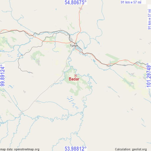
Badar GPS coordinates[2]
54° 23' 58.128" North, 100° 35' 39.696" East
| Map corner | latitude | longitude |
|---|---|---|
| Upper-left | 54.80675°, | 99.89124° |
| Center: | 54.39948°, | 100.59436° |
| Lower-right: | 53.98812°, | 101.29749° |
| Map W x H: | 91×91 km | = 56.5×56.5mi |
| max Lat: | 73.50819° ⇑52% North |
| Badar: | 54.39948° |
| min Lat: | ⇓48% South 41.28413° |
| min Long | Badar | max Long |
| -179.12198° | 100.59436° | 179.35046° |
| W 88.3%⇐ | ⇒11.7% E |
Elevation
Elevation of Badar is 488 m = 1601 ft, and this is 285.4 m = 936 ft above average elevation for this country.
| Max E: |
2518 m = 8261 ft | 8.6% |
| Badar | 488 m 1601 ft | |
| Avg. | 202.6 m = 665 ft | |
Min E: |
-28 m = -92 ft | 91.4% |
See also: Russia elevation on elevation.city.
Geographical zone
Badar is located in North temperate zone (between Tropic of Cancer and the Arctic Circle). Distance of this North polar circle is 1352.5 km =840.4 mi to North.| Distance of | km | miles | from Badar |
|---|---|---|---|
| North Pole | 3958.4 | 2459.6 | to North |
| Arctic Circle | 1352.5 | 840.4 | to North |
| Tropic Cancer | 3442.7 | 2139.2 | to South |
| Equator | 6048.7 | 3758.5 | to South |


Nearby cities:
15 places around Badar: (largest is in red/bold)
• Afanas’yeva
26.7 km =16.6 mi,  3°
3°
• Algatuy
22 km =13.7 mi,  270°
270°
• Budagovo
39.1 km =24.3 mi,  310°
310°
• Gadaley
9.5 km =5.9 mi,  87°
87°
• Guran
40.4 km =25.1 mi, 4°
• Kotik
29.4 km =18.3 mi,  342°
342°
• Mugun
23.8 km =14.8 mi,  289°
289°
• Perfilovo
7.2 km =4.5 mi,  280°
280°
• Sheragul
21.6 km =13.4 mi,  71°
71°
• Tselinnyye Zemli
33.2 km =20.6 mi, 3°
• Tulun
18.3 km =11.4 mi,  357°
357°
• Tulyushka
37.8 km =23.5 mi,  80°
80°
• Vladimirovka
31.1 km =19.3 mi,  216°
216°
• Yedogon
28.1 km =17.5 mi,  235°
235°
• Yevdokimova
15.2 km =9.4 mi,  163°
163°
Sources, notices
• [Note1] Compared only with cities in Russia existing in our database
• [Src1] Map data: © OpenStreetMap contributors (CC-BY-SA)
• [Src2] Other city data from geonames.org with taken over terms of usage.
• [Src3] Geographical zone / Annual Mean Temperature by Robert A. Rohde @ Wikipedia
