Egvekinot geodata
Egvekinot (Chukotka) is a populated place; located in Russia in Asia/Anadyr (GMT+12) time zone. With population of 2,248 people, there are 4051 cities with bigger population in this country. Compared to other cities in Russia, 98.2% of cities are located further ↓South; 100% of cities are located further →East and 96.4% of cities have higher elevation than Egvekinot. Note1


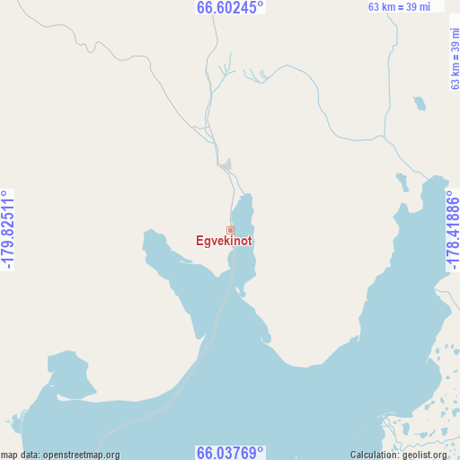
Egvekinot GPS coordinates[2]
66° 19' 17.976" North, 179° 7' 19.128" West
| Map corner | latitude | longitude |
|---|---|---|
| Upper-left | 66.60245°, | -179.82511° |
| Center: | 66.32166°, | -179.12198° |
| Lower-right: | 66.03769°, | -178.41886° |
| Map W x H: | 62.8×62.8 km | = 39×39mi |
| max Lat: | 73.50819° ⇑1.8% North |
| Egvekinot: | 66.32166° |
| min Lat: | ⇓98.2% South 41.28413° |
| min Long | Egvekinot | max Long |
| -179.12198° | -179.12198° | 179.35046° |
| W 0%⇐ | ⇒100% E |
Elevation
Elevation of Egvekinot is 9 m = 30 ft, and this is 193.6 m = 635 ft below average elevation for this country.
| Max E: |
2518 m = 8261 ft | 96.4% |
| Avg. | 202.6 m = 665 ft | |
| Egvekinot | 9 m = 30 ft | |
Min E: |
-28 m = -92 ft | 3.6% |
See also: Russia elevation on elevation.city.
Geographical zone
Egvekinot is located in North temperate zone (between Tropic of Cancer and the Arctic Circle). Distance of this North polar circle is 26.9 km =16.7 mi to North.| Distance of | km | miles | from Egvekinot |
|---|---|---|---|
| North Pole | 2632.8 | 1635.9 | to North |
| Arctic Circle | 26.9 | 16.7 | to North |
| Tropic Cancer | 4768.4 | 2962.9 | to South |
| Equator | 7374.3 | 4582.2 | to South |


Nearby cities:
15 places around Egvekinot: (largest is in red/bold)
• Anadyr
234.9 km =146 mi,  221°
221°
• Beringovskiy
369.7 km =229.7 mi,  191°
191°
• Bilibino
649.9 km =403.8 mi,  287°
287°
• Cherskiy
868.9 km =539.9 mi, 288°
• Evensk
1151.2 km =715.3 mi,  244°
244°
• Kamenskoye
822 km =510.8 mi, 238°
• Lavrentiya
375.8 km =233.5 mi,  102°
102°
• Leningradskiy
353.4 km =219.6 mi,  342°
342°
• Lorino
348.5 km =216.5 mi,  105°
105°
• Ossora
1191.9 km =740.6 mi,  228°
228°
• Pevek
577.7 km =359 mi,  310°
310°
• Provideniya
345 km =214.4 mi,  127°
127°
• Srednekolymsk
1183 km =735.1 mi,  276°
276°
• Tilichiki
982.9 km =610.7 mi, 228°
• Uelen
417.2 km =259.2 mi,  92°
92°
In other languages:
- In German: Egwekinot
- In Italian: Ėgvekinot
- In Russian: Эгвекинот
- In Chinese: 埃格韦基诺特
Sources, notices
• [Note1] Compared only with cities in Russia existing in our database
• [Src1] Map data: © OpenStreetMap contributors (CC-BY-SA)
• [Src2] Other city data from geonames.org with taken over terms of usage.
• [Src3] Geographical zone / Annual Mean Temperature by Robert A. Rohde @ Wikipedia
