Novolisikha geodata
Novolisikha (Irkutsk Oblast) is a populated place; located in Russia in Asia/Irkutsk (GMT+8) time zone. With population of 528 people, there are 4946 cities with bigger population in this country. Compared to other cities in Russia, 67.7% of cities are located further ↑North; 89.6% of cities are located further ←West and 91.6% of cities have lower elevation than Novolisikha. Note1


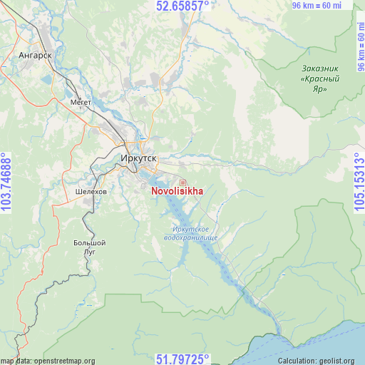
Novolisikha GPS coordinates[2]
52° 13' 48" North, 104° 27' 0" East
| Map corner | latitude | longitude |
|---|---|---|
| Upper-left | 52.65857°, | 103.74688° |
| Center: | 52.23°, | 104.45° |
| Lower-right: | 51.79725°, | 105.15313° |
| Map W x H: | 95.8×95.8 km | = 59.5×59.5mi |
| max Lat: | 73.50819° ⇑67.7% North |
| Novolisikha: | 52.23° |
| min Lat: | ⇓32.3% South 41.28413° |
| min Long | Novolisikha | max Long |
| -179.12198° | 104.45° | 179.35046° |
| W 89.6%⇐ | ⇒10.4% E |
Elevation
Elevation of Novolisikha is 492 m = 1614 ft, and this is 289.4 m = 949 ft above average elevation for this country.
| Max E: |
2518 m = 8261 ft | 8.4% |
| Novolisikha | 492 m 1614 ft | |
| Avg. | 202.6 m = 665 ft | |
Min E: |
-28 m = -92 ft | 91.6% |
See also: Russia elevation on elevation.city.
Geographical zone
Novolisikha is located in North temperate zone (between Tropic of Cancer and the Arctic Circle). Distance of this North polar circle is 1593.7 km =990.3 mi to North.| Distance of | km | miles | from Novolisikha |
|---|---|---|---|
| North Pole | 4199.6 | 2609.5 | to North |
| Arctic Circle | 1593.7 | 990.3 | to North |
| Tropic Cancer | 3201.5 | 1989.3 | to South |
| Equator | 5807.4 | 3608.5 | to South |


Nearby cities:
15 places around Novolisikha: (largest is in red/bold)
• Baklashi
27.3 km =17 mi,  268°
268°
• Bol’shaya Rechka
36.3 km =22.6 mi,  147°
147°
• Chistyye Klyuchi
34.7 km =21.6 mi,  260°
260°
• Dzerzhinsk
7 km =4.3 mi,  322°
322°
• Irkutsk
12.9 km =8 mi,  305°
305°
• Khomutovo
26.4 km =16.4 mi,  352°
352°
• Markova
16.5 km =10.3 mi, 261°
• Meget
34.1 km =21.2 mi, 307°
• Oyëk
39.6 km =24.6 mi,  0°
0°
• Pad’ Mel’nichnaya
9.1 km =5.7 mi,  211°
211°
• Pivovarikha
4.5 km =2.8 mi,  356°
356°
• Shelekhov
23.9 km =14.9 mi, 265°
• Smolenshchina
22.1 km =13.7 mi,  277°
277°
• Urik
29.3 km =18.2 mi,  330°
330°
• Vvedenshchina
34.6 km =21.5 mi, 265°
Sources, notices
• [Note1] Compared only with cities in Russia existing in our database
• [Src1] Map data: © OpenStreetMap contributors (CC-BY-SA)
• [Src2] Other city data from geonames.org with taken over terms of usage.
• [Src3] Geographical zone / Annual Mean Temperature by Robert A. Rohde @ Wikipedia
