Zhilëvo geodata
Zhilëvo (Moscow Oblast) is a populated place; located in Russia in Europe/Moscow (GMT+3) time zone. With population of 2,600 people, there are 3921 cities with bigger population in this country. Compared to other cities in Russia, 53.4% of cities are located further ↓South; 77.2% of cities are located further →East and 59.2% of cities have lower elevation than Zhilëvo. Note1


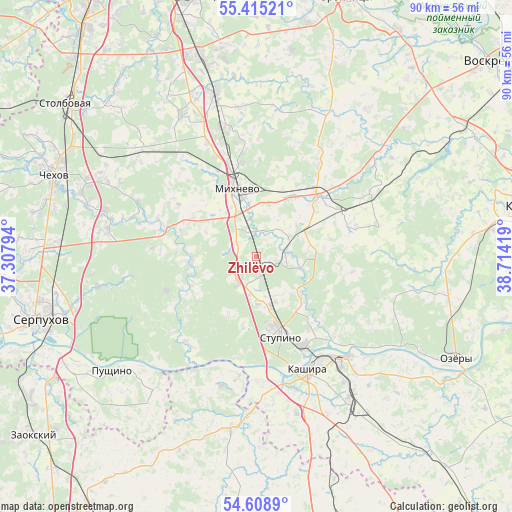
Zhilëvo GPS coordinates[2]
55° 0' 50.688" North, 38° 0' 39.816" East
| Map corner | latitude | longitude |
|---|---|---|
| Upper-left | 55.41521°, | 37.30794° |
| Center: | 55.01408°, | 38.01106° |
| Lower-right: | 54.6089°, | 38.71419° |
| Map W x H: | 89.7×89.7 km | = 55.7×55.7mi |
| max Lat: | 73.50819° ⇑46.6% North |
| Zhilëvo: | 55.01408° |
| min Lat: | ⇓53.4% South 41.28413° |
| min Long | Zhilëvo | max Long |
| -179.12198° | 38.01106° | 179.35046° |
| W 22.8%⇐ | ⇒77.2% E |
Elevation
Elevation of Zhilëvo is 166 m = 545 ft, and this is 36.6 m = 120 ft below average elevation for this country.
| Max E: |
2518 m = 8261 ft | 40.8% |
| Avg. | 202.6 m = 665 ft | |
| Zhilëvo | 166 m = 545 ft | |
Min E: |
-28 m = -92 ft | 59.2% |
See also: Russia elevation on elevation.city.
Geographical zone
Zhilëvo is located in North temperate zone (between Tropic of Cancer and the Arctic Circle). Distance of this North polar circle is 1284.2 km =798 mi to North.| Distance of | km | miles | from Zhilëvo |
|---|---|---|---|
| North Pole | 3890.1 | 2417.2 | to North |
| Arctic Circle | 1284.2 | 798 | to North |
| Tropic Cancer | 3511.1 | 2181.7 | to South |
| Equator | 6117 | 3800.9 | to South |


Nearby cities:
15 places around Zhilëvo: (largest is in red/bold)
• Barybino
29.2 km =18.1 mi,  345°
345°
• Bol’shoye Gryzlovo
33.6 km =20.9 mi,  224°
224°
• Danki
30.1 km =18.7 mi,  249°
249°
• Il’inskoye
26.4 km =16.4 mi, 352°
• Kashira
21.3 km =13.2 mi,  152°
152°
• Malino
15 km =9.3 mi,  43°
43°
• Melikhovo
25.7 km =16 mi,  295°
295°
• Meshcherino
30 km =18.6 mi,  47°
47°
• Mikhnëvo
13.1 km =8.1 mi,  344°
344°
• Novyy Byt
25.8 km =16 mi,  281°
281°
• Ozherel’ye
29.6 km =18.4 mi, 146°
• Popovo
22.9 km =14.2 mi,  287°
287°
• Pushchino
32.5 km =20.2 mi,  231°
231°
• Sharapova Okhota
34 km =21.1 mi,  274°
274°
• Stupino
13.2 km =8.2 mi,  163°
163°
Sources, notices
• [Note1] Compared only with cities in Russia existing in our database
• [Src1] Map data: © OpenStreetMap contributors (CC-BY-SA)
• [Src2] Other city data from geonames.org with taken over terms of usage.
• [Src3] Geographical zone / Annual Mean Temperature by Robert A. Rohde @ Wikipedia
