Yugo-Kamskiy geodata
Yugo-Kamskiy (Perm) is a populated place; located in Russia in Asia/Yekaterinburg (GMT+5) time zone. With population of 7,779 people, there are 1857 cities with bigger population in this country. Compared to other cities in Russia, 81% of cities are located further ↓South; 67% of cities are located further ←West and 61.4% of cities have higher elevation than Yugo-Kamskiy. Note1


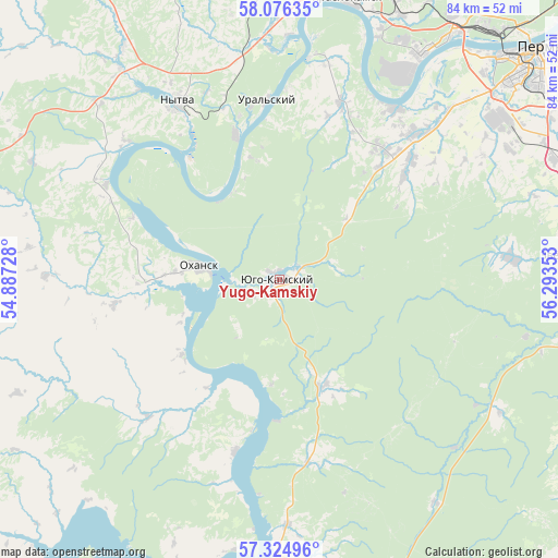
Yugo-Kamskiy GPS coordinates[2]
57° 42' 9.36" North, 55° 35' 25.44" East
| Map corner | latitude | longitude |
|---|---|---|
| Upper-left | 58.07635°, | 54.88728° |
| Center: | 57.7026°, | 55.5904° |
| Lower-right: | 57.32496°, | 56.29353° |
| Map W x H: | 83.5×83.5 km | = 51.9×51.9mi |
| max Lat: | 73.50819° ⇑19% North |
| Yugo-Kamskiy: | 57.7026° |
| min Lat: | ⇓81% South 41.28413° |
| min Long | Yugo-Kamskiy | max Long |
| -179.12198° | 55.5904° | 179.35046° |
| W 67%⇐ | ⇒33% E |
Elevation
Elevation of Yugo-Kamskiy is 121 m = 397 ft, and this is 81.6 m = 268 ft below average elevation for this country.
| Max E: |
2518 m = 8261 ft | 61.4% |
| Avg. | 202.6 m = 665 ft | |
| Yugo-Kamskiy | 121 m = 397 ft | |
Min E: |
-28 m = -92 ft | 38.6% |
See also: Russia elevation on elevation.city.
Geographical zone
Yugo-Kamskiy is located in North temperate zone (between Tropic of Cancer and the Arctic Circle). Distance of this North polar circle is 985.2 km =612.2 mi to North.| Distance of | km | miles | from Yugo-Kamskiy |
|---|---|---|---|
| North Pole | 3591.1 | 2231.4 | to North |
| Arctic Circle | 985.2 | 612.2 | to North |
| Tropic Cancer | 3810 | 2367.4 | to South |
| Equator | 6415.9 | 3986.7 | to South |


Nearby cities:
15 places around Yugo-Kamskiy: (largest is in red/bold)
• Bershet’
46.9 km =29.1 mi,  86°
86°
• Froly
47.2 km =29.3 mi,  58°
58°
• Gamovo
35.5 km =22.1 mi, 59°
• Kondratovo
43.4 km =27 mi,  44°
44°
• Krasnokamsk
43 km =26.7 mi,  13°
13°
• Kultayevo
29.7 km =18.5 mi, 43°
• Lobanovo
45.7 km =28.4 mi,  67°
67°
• Nytva
30.6 km =19 mi,  331°
331°
• Okhansk
12.2 km =7.6 mi,  279°
279°
• Overyata
45.5 km =28.3 mi,  21°
21°
• Pavlovskiy
46.9 km =29.1 mi,  289°
289°
• Sokol
35.8 km =22.2 mi,  48°
48°
• Ust’-Kachka
33.8 km =21 mi, 8°
• Yug
34.7 km =21.6 mi, 85°
• Zvëzdnyy
43.1 km =26.8 mi, 85°
Sources, notices
• [Note1] Compared only with cities in Russia existing in our database
• [Src1] Map data: © OpenStreetMap contributors (CC-BY-SA)
• [Src2] Other city data from geonames.org with taken over terms of usage.
• [Src3] Geographical zone / Annual Mean Temperature by Robert A. Rohde @ Wikipedia
