Volodarskiy geodata
Volodarskiy (Astrakhan) is a populated place; located in Russia in Europe/Astrakhan (GMT+4) time zone. With population of 9,509 people, there are 1590 cities with bigger population in this country. Compared to other cities in Russia, 83.2% of cities are located further ↑North; 60.2% of cities are located further ←West and 99.5% of cities have higher elevation than Volodarskiy. Note1


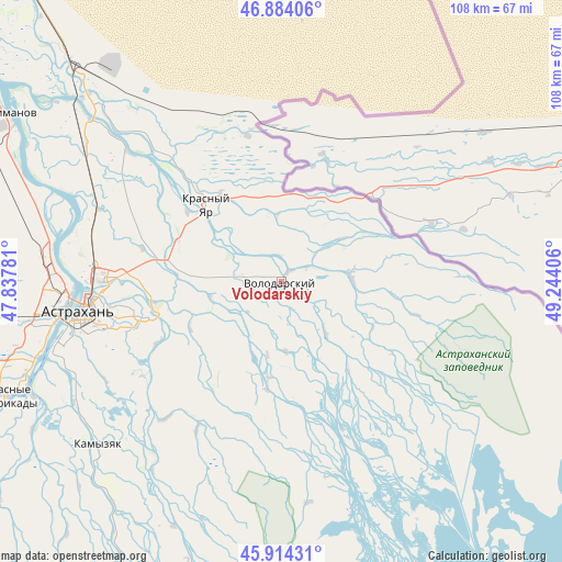
Volodarskiy GPS coordinates[2]
46° 24' 4.824" North, 48° 32' 27.348" East
| Map corner | latitude | longitude |
|---|---|---|
| Upper-left | 46.88406°, | 47.83781° |
| Center: | 46.40134°, | 48.54093° |
| Lower-right: | 45.91431°, | 49.24406° |
| Map W x H: | 107.8×107.8 km | = 67×67mi |
| max Lat: | 73.50819° ⇑83.2% North |
| Volodarskiy: | 46.40134° |
| min Lat: | ⇓16.8% South 41.28413° |
| min Long | Volodarskiy | max Long |
| -179.12198° | 48.54093° | 179.35046° |
| W 60.2%⇐ | ⇒39.8% E |
Elevation
Elevation of Volodarskiy is -19 m = -62 ft, and this is 221.6 m = 727 ft below average elevation for this country.
| Max E: |
2518 m = 8261 ft | 99.5% |
| Avg. | 202.6 m = 665 ft | |
| Volodarskiy | -19 m = -62 ft | |
Min E: |
-28 m = -92 ft | 0.5% |
See also: Russia elevation on elevation.city.
Geographical zone
Volodarskiy is located in North temperate zone (between Tropic of Cancer and the Arctic Circle). Distance of this North polar circle is 2241.8 km =1393 mi to North.| Distance of | km | miles | from Volodarskiy |
|---|---|---|---|
| North Pole | 4847.7 | 3012.2 | to North |
| Arctic Circle | 2241.8 | 1393 | to North |
| Tropic Cancer | 2553.4 | 1586.6 | to South |
| Equator | 5159.3 | 3205.8 | to South |


Nearby cities:
15 places around Volodarskiy: (largest is in red/bold)
• Altynzhar
14.3 km =8.9 mi,  190°
190°
• Astrakhan
38.8 km =24.1 mi,  261°
261°
• Kamyzyak
48.4 km =30.1 mi,  227°
227°
• Karalat
56.9 km =35.4 mi,  198°
198°
• Krasnyy Yar
20.9 km =13 mi,  314°
314°
• Marfino
13.3 km =8.3 mi,  86°
86°
• Mirnyy
47.9 km =29.8 mi,  266°
266°
• Nachalovo
27 km =16.8 mi,  254°
254°
• Sizyy Bugor
21.1 km =13.1 mi, 187°
• Solyanka
40.2 km =25 mi, 268°
• Starokucherganovka
45.7 km =28.4 mi, 259°
• Tumak
18.8 km =11.7 mi, 188°
• Uvary
55.4 km =34.4 mi,  224°
224°
• Volgo-Kaspiyskiy
52.6 km =32.7 mi, 245°
• Yaksatovo
44 km =27.3 mi, 246°
Sources, notices
• [Note1] Compared only with cities in Russia existing in our database
• [Src1] Map data: © OpenStreetMap contributors (CC-BY-SA)
• [Src2] Other city data from geonames.org with taken over terms of usage.
• [Src3] Geographical zone / Annual Mean Temperature by Robert A. Rohde @ Wikipedia
