Sviblovo geodata
Sviblovo (Moscow) is a section of populated place; located in Russia in Europe/Moscow (GMT+3) time zone. With population of 60,000 people, there are 353 cities with bigger population in this country. Compared to other cities in Russia, 64.3% of cities are located further ↓South; 80.3% of cities are located further →East and 50.4% of cities have lower elevation than Sviblovo. Note1


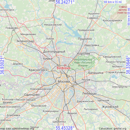
Sviblovo GPS coordinates[2]
55° 51' 0" North, 37° 37' 59.988" East
| Map corner | latitude | longitude |
|---|---|---|
| Upper-left | 56.24271°, | 36.93021° |
| Center: | 55.85°, | 37.63333° |
| Lower-right: | 55.45328°, | 38.33646° |
| Map W x H: | 87.8×87.8 km | = 54.6×54.6mi |
| max Lat: | 73.50819° ⇑35.7% North |
| Sviblovo: | 55.85° |
| min Lat: | ⇓64.3% South 41.28413° |
| min Long | Sviblovo | max Long |
| -179.12198° | 37.63333° | 179.35046° |
| W 19.7%⇐ | ⇒80.3% E |
Elevation
Elevation of Sviblovo is 145 m = 476 ft, and this is 57.6 m = 189 ft below average elevation for this country.
| Max E: |
2518 m = 8261 ft | 49.6% |
| Avg. | 202.6 m = 665 ft | |
| Sviblovo | 145 m = 476 ft | |
Min E: |
-28 m = -92 ft | 50.4% |
See also: Sviblovo elevation on elevation.city.
Geographical zone
Sviblovo is located in North temperate zone (between Tropic of Cancer and the Arctic Circle). Distance of this North polar circle is 1191.2 km =740.2 mi to North.| Distance of | km | miles | from Sviblovo |
|---|---|---|---|
| North Pole | 3797.1 | 2359.4 | to North |
| Arctic Circle | 1191.2 | 740.2 | to North |
| Tropic Cancer | 3604 | 2239.4 | to South |
| Equator | 6209.9 | 3858.7 | to South |


Nearby cities:
15 places around Sviblovo: (largest is in red/bold)
• Altuf’yevskiy
4.8 km =3 mi,  319°
319°
• Bibirevo
4.2 km =2.6 mi,  330°
330°
• Kozeyevo
2.1 km =1.3 mi, 330°
• Leonovo
1 km =0.6 mi,  90°
90°
• Lianozovo
6.1 km =3.8 mi, 331°
• Likhobory
4.2 km =2.6 mi,  270°
270°
• Novovladykino
3.1 km =1.9 mi, 270°
• Ostankinskiy
2.5 km =1.6 mi,  205°
205°
• Otradnoye
2.8 km =1.7 mi,  311°
311°
• Rostokino
2.8 km =1.7 mi,  131°
131°
• Slobodka
3.6 km =2.2 mi,  300°
300°
• Sokol’niki
5.8 km =3.6 mi,  155°
155°
• Vatutino
5.2 km =3.2 mi,  43°
43°
• Vostochnoe Degunino
5.8 km =3.6 mi, 305°
• Yaroslavskiy
6.4 km =4 mi,  54°
54°
Sources, notices
• [Note1] Compared only with cities in Russia existing in our database
• [Src1] Map data: © OpenStreetMap contributors (CC-BY-SA)
• [Src2] Other city data from geonames.org with taken over terms of usage.
• [Src3] Geographical zone / Annual Mean Temperature by Robert A. Rohde @ Wikipedia
