Alpatovo geodata
Alpatovo (Chechnya) is a populated place; located in Russia in Europe/Moscow (GMT+3) time zone. With population of 5,192 people, there are 2564 cities with bigger population in this country. Compared to other cities in Russia, 93% of cities are located further ↑North; 50.8% of cities are located further ←West and 73.4% of cities have higher elevation than Alpatovo. Note1


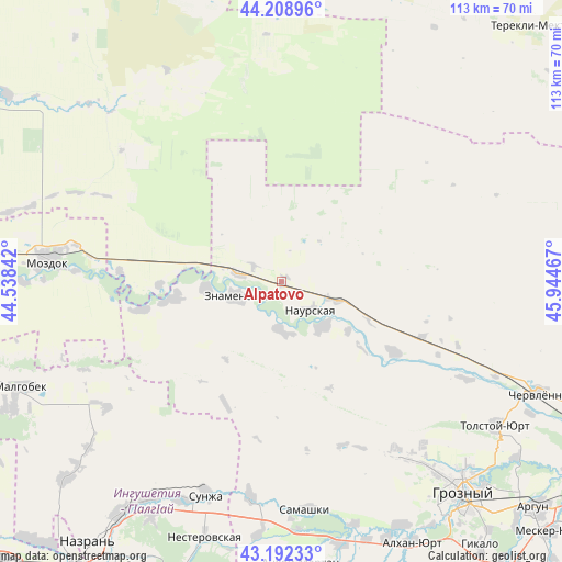
Alpatovo GPS coordinates[2]
43° 42' 10.08" North, 45° 14' 29.544" East
| Map corner | latitude | longitude |
|---|---|---|
| Upper-left | 44.20896°, | 44.53842° |
| Center: | 43.7028°, | 45.24154° |
| Lower-right: | 43.19233°, | 45.94467° |
| Map W x H: | 113×113 km | = 70.2×70.2mi |
| max Lat: | 73.50819° ⇑93% North |
| Alpatovo: | 43.7028° |
| min Lat: | ⇓7% South 41.28413° |
| min Long | Alpatovo | max Long |
| -179.12198° | 45.24154° | 179.35046° |
| W 50.8%⇐ | ⇒49.2% E |
Elevation
Elevation of Alpatovo is 93 m = 305 ft, and this is 109.6 m = 360 ft below average elevation for this country.
| Max E: |
2518 m = 8261 ft | 73.4% |
| Avg. | 202.6 m = 665 ft | |
| Alpatovo | 93 m = 305 ft | |
Min E: |
-28 m = -92 ft | 26.6% |
See also: Russia elevation on elevation.city.
Geographical zone
Alpatovo is located in North temperate zone (between Tropic of Cancer and the Arctic Circle). Distance of this Northern Tropic circle is 2253.4 km =1400.2 mi to South.| Distance of | km | miles | from Alpatovo |
|---|---|---|---|
| North Pole | 5147.8 | 3198.7 | to North |
| Arctic Circle | 2541.9 | 1579.5 | to North |
| Tropic Cancer | 2253.4 | 1400.2 | to South |
| Equator | 4859.3 | 3019.4 | to South |


Nearby cities:
15 places around Alpatovo: (largest is in red/bold)
• Benoy-Yurt
15.4 km =9.6 mi,  265°
265°
• Elin-Yurt
23 km =14.3 mi,  261°
261°
• Galyugayevskaya
24.7 km =15.3 mi, 268°
• Goragorskiy
25.8 km =16 mi,  209°
209°
• Ishcherskaya
8.7 km =5.4 mi,  277°
277°
• Kalinovskaya
26.7 km =16.6 mi,  122°
122°
• Lakha Nëvre
11.9 km =7.4 mi,  138°
138°
• Lakkha Nëvre
10.3 km =6.4 mi,  178°
178°
• Naurskaya
8.1 km =5 mi, 135°
• Nogamerzin-Yurt
28.9 km =18 mi, 259°
• Pervomayskaya
40.3 km =25 mi,  145°
145°
• Sernovodsk
43.9 km =27.3 mi,  188°
188°
• Terskaya
41.6 km =25.8 mi, 273°
• Voznesenskaya
43.6 km =27.1 mi,  246°
246°
• Znamenskoye
9.5 km =5.9 mi, 253°
Sources, notices
• [Note1] Compared only with cities in Russia existing in our database
• [Src1] Map data: © OpenStreetMap contributors (CC-BY-SA)
• [Src2] Other city data from geonames.org with taken over terms of usage.
• [Src3] Geographical zone / Annual Mean Temperature by Robert A. Rohde @ Wikipedia
