Lazarevskoye geodata
Lazarevskoye (Krasnodarskiy) is a populated place; located in Russia in Europe/Moscow (GMT+3) time zone. With population of 30,000 people, there are 646 cities with bigger population in this country. Compared to other cities in Russia, 92.3% of cities are located further ↑North; 70.8% of cities are located further →East and 95.9% of cities have higher elevation than Lazarevskoye. Note1


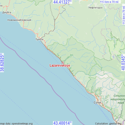
Lazarevskoye GPS coordinates[2]
43° 54' 31.896" North, 39° 19' 52.932" East
| Map corner | latitude | longitude |
|---|---|---|
| Upper-left | 44.41327°, | 38.62825° |
| Center: | 43.90886°, | 39.33137° |
| Lower-right: | 43.40014°, | 40.0345° |
| Map W x H: | 112.6×112.6 km | = 70×70mi |
| max Lat: | 73.50819° ⇑92.3% North |
| Lazarevskoye: | 43.90886° |
| min Lat: | ⇓7.7% South 41.28413° |
| min Long | Lazarevskoye | max Long |
| -179.12198° | 39.33137° | 179.35046° |
| W 29.2%⇐ | ⇒70.8% E |
Elevation
Elevation of Lazarevskoye is 10 m = 33 ft, and this is 192.6 m = 632 ft below average elevation for this country.
| Max E: |
2518 m = 8261 ft | 95.9% |
| Avg. | 202.6 m = 665 ft | |
| Lazarevskoye | 10 m = 33 ft | |
Min E: |
-28 m = -92 ft | 4.1% |
See also: Russia elevation on elevation.city.
Geographical zone
Lazarevskoye is located in North temperate zone (between Tropic of Cancer and the Arctic Circle). Distance of this Northern Tropic circle is 2276.3 km =1414.4 mi to South.| Distance of | km | miles | from Lazarevskoye |
|---|---|---|---|
| North Pole | 5124.9 | 3184.5 | to North |
| Arctic Circle | 2519 | 1565.2 | to North |
| Tropic Cancer | 2276.3 | 1414.4 | to South |
| Equator | 4882.2 | 3033.7 | to South |


Nearby cities:
15 places around Lazarevskoye: (largest is in red/bold)
• Agoy
35.4 km =22 mi,  318°
318°
• Ashe
6.8 km =4.2 mi, 321°
• Dagomys
37.9 km =23.5 mi,  134°
134°
• Gornoye Loo
30.9 km =19.2 mi, 134°
• Khadyzhensk
59.8 km =37.2 mi,  15°
15°
• Khosta
61.5 km =38.2 mi,  135°
135°
• Mezmay
59.9 km =37.2 mi,  57°
57°
• Nebug
39.3 km =24.4 mi, 318°
• Neftegorsk
59 km =36.7 mi,  30°
30°
• Novomikhaylovskiy
54.5 km =33.9 mi, 316°
• Ol’ginka
48.4 km =30.1 mi,  313°
313°
• Shepsi
20.4 km =12.7 mi, 313°
• Sochi
46.8 km =29.1 mi, 137°
• Tuapse
29.7 km =18.5 mi, 317°
• Vardane
26.6 km =16.5 mi, 137°
Sources, notices
• [Note1] Compared only with cities in Russia existing in our database
• [Src1] Map data: © OpenStreetMap contributors (CC-BY-SA)
• [Src2] Other city data from geonames.org with taken over terms of usage.
• [Src3] Geographical zone / Annual Mean Temperature by Robert A. Rohde @ Wikipedia
