Laptëvo geodata
Laptëvo (Pskov Oblast) is a seat of a third-order administrative division; located in Russia in Europe/Moscow (GMT+3) time zone. In our database, there are 4966 cities with bigger population. Compared to other cities in Russia, 74.7% of cities are located further ↓South; 98.4% of cities are located further →East and 67.2% of cities have higher elevation than Laptëvo. Note1


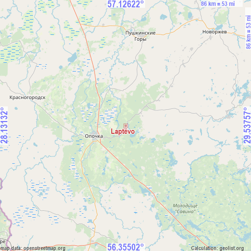
Laptëvo GPS coordinates[2]
56° 44' 33.36" North, 28° 50' 3.984" East
| Map corner | latitude | longitude |
|---|---|---|
| Upper-left | 57.12622°, | 28.13132° |
| Center: | 56.7426°, | 28.83444° |
| Lower-right: | 56.35502°, | 29.53757° |
| Map W x H: | 85.7×85.7 km | = 53.3×53.3mi |
| max Lat: | 73.50819° ⇑25.3% North |
| Laptëvo: | 56.7426° |
| min Lat: | ⇓74.7% South 41.28413° |
| min Long | Laptëvo | max Long |
| -179.12198° | 28.83444° | 179.35046° |
| W 1.6%⇐ | ⇒98.4% E |
Elevation
Elevation of Laptëvo is 109 m = 358 ft, and this is 93.6 m = 307 ft below average elevation for this country.
| Max E: |
2518 m = 8261 ft | 67.2% |
| Avg. | 202.6 m = 665 ft | |
| Laptëvo | 109 m = 358 ft | |
Min E: |
-28 m = -92 ft | 32.8% |
See also: Russia elevation on elevation.city.
Geographical zone
Laptëvo is located in North temperate zone (between Tropic of Cancer and the Arctic Circle). Distance of this North polar circle is 1092 km =678.5 mi to North.| Distance of | km | miles | from Laptëvo |
|---|---|---|---|
| North Pole | 3697.9 | 2297.8 | to North |
| Arctic Circle | 1092 | 678.5 | to North |
| Tropic Cancer | 3703.3 | 2301.1 | to South |
| Equator | 6309.2 | 3920.4 | to South |


Nearby cities:
15 places around Laptëvo: (largest is in red/bold)
• Bolgatovo
9.7 km =6 mi,  46°
46°
• Glubokoye
18.7 km =11.6 mi,  142°
142°
• Il’inskoye
27.6 km =17.1 mi,  316°
316°
• Lukino
26 km =16.2 mi,  299°
299°
• Makushino
22.9 km =14.2 mi,  254°
254°
• Matyushkino
18.5 km =11.5 mi, 316°
• Norkino
14.5 km =9 mi,  124°
124°
• Opochka
10.9 km =6.8 mi, 252°
• Petrovskoye
12.6 km =7.8 mi, 246°
• Polyane
15.7 km =9.8 mi,  11°
11°
• Pushkinskiye Gory
31.3 km =19.4 mi, 8°
• Varygino
18.4 km =11.4 mi,  276°
276°
• Vel’ye
29.7 km =18.5 mi,  328°
328°
• Zanogi
25.2 km =15.7 mi,  161°
161°
• Zvony
13.2 km =8.2 mi,  184°
184°
Sources, notices
• [Note1] Compared only with cities in Russia existing in our database
• [Src1] Map data: © OpenStreetMap contributors (CC-BY-SA)
• [Src2] Other city data from geonames.org with taken over terms of usage.
• [Src3] Geographical zone / Annual Mean Temperature by Robert A. Rohde @ Wikipedia
