Krasnofarfornyy geodata
Krasnofarfornyy (Novgorod Oblast) is a populated place; located in Russia in Europe/Moscow (GMT+3) time zone. With population of 1,613 people, there are 4329 cities with bigger population in this country. Compared to other cities in Russia, 86.8% of cities are located further ↓South; 93.7% of cities are located further →East and 91.1% of cities have higher elevation than Krasnofarfornyy. Note1


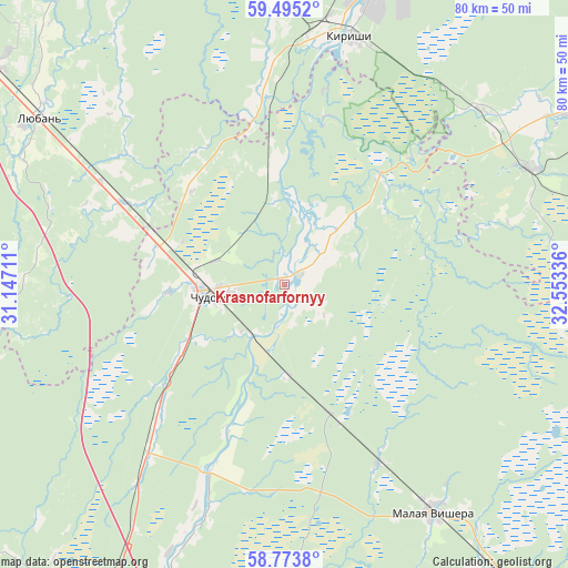
Krasnofarfornyy GPS coordinates[2]
59° 8' 11.04" North, 31° 51' 0.828" East
| Map corner | latitude | longitude |
|---|---|---|
| Upper-left | 59.4952°, | 31.14711° |
| Center: | 59.1364°, | 31.85023° |
| Lower-right: | 58.7738°, | 32.55336° |
| Map W x H: | 80.2×80.2 km | = 49.8×49.8mi |
| max Lat: | 73.50819° ⇑13.2% North |
| Krasnofarfornyy: | 59.1364° |
| min Lat: | ⇓86.8% South 41.28413° |
| min Long | Krasnofarfornyy | max Long |
| -179.12198° | 31.85023° | 179.35046° |
| W 6.3%⇐ | ⇒93.7% E |
Elevation
Elevation of Krasnofarfornyy is 24 m = 79 ft, and this is 178.6 m = 586 ft below average elevation for this country.
| Max E: |
2518 m = 8261 ft | 91.1% |
| Avg. | 202.6 m = 665 ft | |
| Krasnofarfornyy | 24 m = 79 ft | |
Min E: |
-28 m = -92 ft | 8.9% |
See also: Russia elevation on elevation.city.
Geographical zone
Krasnofarfornyy is located in North temperate zone (between Tropic of Cancer and the Arctic Circle). Distance of this North polar circle is 825.8 km =513.1 mi to North.| Distance of | km | miles | from Krasnofarfornyy |
|---|---|---|---|
| North Pole | 3431.7 | 2132.4 | to North |
| Arctic Circle | 825.8 | 513.1 | to North |
| Tropic Cancer | 3969.4 | 2466.5 | to South |
| Equator | 6575.4 | 4085.8 | to South |


Nearby cities:
15 places around Krasnofarfornyy: (largest is in red/bold)
• Budogoshch’
38.8 km =24.1 mi,  65°
65°
• Chudovo
9.8 km =6.1 mi,  257°
257°
• Kholm
58.7 km =36.5 mi,  75°
75°
• Kirishi
35.9 km =22.3 mi,  15°
15°
• Krechevitsy
63.3 km =39.3 mi,  204°
204°
• Lyuban’
43.1 km =26.8 mi,  303°
303°
• Malaya Vishera
38.7 km =24 mi,  146°
146°
• Mga
81.3 km =50.5 mi,  327°
327°
• Nurma
65.9 km =40.9 mi,  314°
314°
• Pankovka
80.1 km =49.8 mi,  207°
207°
• Proletariy
78.5 km =48.8 mi,  186°
186°
• Ryabovo
50.2 km =31.2 mi, 305°
• Tosno
71.1 km =44.2 mi, 309°
• Velikiy Novgorod
76.1 km =47.3 mi, 205°
• Volkhovskiy
69.1 km =42.9 mi, 206°
Sources, notices
• [Note1] Compared only with cities in Russia existing in our database
• [Src1] Map data: © OpenStreetMap contributors (CC-BY-SA)
• [Src2] Other city data from geonames.org with taken over terms of usage.
• [Src3] Geographical zone / Annual Mean Temperature by Robert A. Rohde @ Wikipedia
