Kozel’sk geodata
Kozel’sk (Kaluga) is a populated place; located in Russia in Europe/Moscow (GMT+3) time zone. With population of 19,500 people, there are 893 cities with bigger population in this country. Compared to other cities in Russia, 54.9% of cities are located further ↑North; 87.9% of cities are located further →East and 60.6% of cities have lower elevation than Kozel’sk. Note1


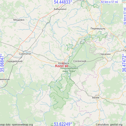
Kozel’sk GPS coordinates[2]
54° 2' 14.856" North, 35° 46' 17.724" East
| Map corner | latitude | longitude |
|---|---|---|
| Upper-left | 54.44833°, | 35.06847° |
| Center: | 54.03746°, | 35.77159° |
| Lower-right: | 53.62249°, | 36.47472° |
| Map W x H: | 91.8×91.8 km | = 57×57mi |
| max Lat: | 73.50819° ⇑54.9% North |
| Kozel’sk: | 54.03746° |
| min Lat: | ⇓45.1% South 41.28413° |
| min Long | Kozel’sk | max Long |
| -179.12198° | 35.77159° | 179.35046° |
| W 12.1%⇐ | ⇒87.9% E |
Elevation
Elevation of Kozel’sk is 170 m = 558 ft, and this is 32.6 m = 107 ft below average elevation for this country.
| Max E: |
2518 m = 8261 ft | 39.4% |
| Avg. | 202.6 m = 665 ft | |
| Kozel’sk | 170 m = 558 ft | |
Min E: |
-28 m = -92 ft | 60.6% |
See also: Russia elevation on elevation.city.
Geographical zone
Kozel’sk is located in North temperate zone (between Tropic of Cancer and the Arctic Circle). Distance of this North polar circle is 1392.8 km =865.4 mi to North.| Distance of | km | miles | from Kozel’sk |
|---|---|---|---|
| North Pole | 3998.7 | 2484.7 | to North |
| Arctic Circle | 1392.8 | 865.4 | to North |
| Tropic Cancer | 3402.5 | 2114.2 | to South |
| Equator | 6008.4 | 3733.4 | to South |


Nearby cities:
15 places around Kozel’sk: (largest is in red/bold)
• Babynino
39.6 km =24.6 mi,  359°
359°
• Belëv
34.4 km =21.4 mi,  136°
136°
• Chekalin
31.6 km =19.6 mi,  77°
77°
• Cherepet’
40.6 km =25.2 mi, 77°
• Deshovki
3.9 km =2.4 mi,  164°
164°
• Duminichi
44.7 km =27.8 mi,  255°
255°
• Meshchovsk
45.1 km =28 mi,  314°
314°
• Peremyshl’
35.7 km =22.2 mi,  45°
45°
• Pesochenskiy
26.8 km =16.7 mi,  55°
55°
• Saburovshchino
44 km =27.3 mi,  349°
349°
• Seredeyskiy
35.3 km =21.9 mi,  272°
272°
• Sosenskiy
12.7 km =7.9 mi, 79°
• Sukhinichi
28.8 km =17.9 mi,  283°
283°
• Vorotynsk
47 km =29.2 mi,  22°
22°
• Zarech’ye
35.3 km =21.9 mi,  194°
194°
Sources, notices
• [Note1] Compared only with cities in Russia existing in our database
• [Src1] Map data: © OpenStreetMap contributors (CC-BY-SA)
• [Src2] Other city data from geonames.org with taken over terms of usage.
• [Src3] Geographical zone / Annual Mean Temperature by Robert A. Rohde @ Wikipedia
