Korzhovka-Golubovka geodata
Korzhovka-Golubovka (Bryansk Oblast) is a populated place; located in Russia in Europe/Moscow (GMT+3) time zone. With population of 2,224 people, there are 4060 cities with bigger population in this country. Compared to other cities in Russia, 64.3% of cities are located further ↑North; 92.9% of cities are located further →East and 60.9% of cities have lower elevation than Korzhovka-Golubovka. Note1


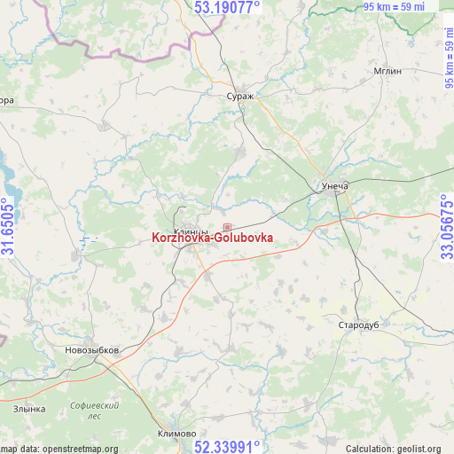
Korzhovka-Golubovka GPS coordinates[2]
52° 46' 2.712" North, 32° 21' 13.032" East
| Map corner | latitude | longitude |
|---|---|---|
| Upper-left | 53.19077°, | 31.6505° |
| Center: | 52.76742°, | 32.35362° |
| Lower-right: | 52.33991°, | 33.05675° |
| Map W x H: | 94.6×94.6 km | = 58.8×58.8mi |
| max Lat: | 73.50819° ⇑64.3% North |
| Korzhovka-Golubovka: | 52.76742° |
| min Lat: | ⇓35.7% South 41.28413° |
| min Long | Korzhovka-Golub | max Long |
| -179.12198° | 32.35362° | 179.35046° |
| W 7.1%⇐ | ⇒92.9% E |
Elevation
Elevation of Korzhovka-Golubovka is 171 m = 561 ft, and this is 31.6 m = 104 ft below average elevation for this country.
| Max E: |
2518 m = 8261 ft | 39.1% |
| Avg. | 202.6 m = 665 ft | |
| Korzhovka-Golubovka | 171 m = 561 ft | |
Min E: |
-28 m = -92 ft | 60.9% |
See also: Russia elevation on elevation.city.
Geographical zone
Korzhovka-Golubovka is located in North temperate zone (between Tropic of Cancer and the Arctic Circle). Distance of this North polar circle is 1534 km =953.2 mi to North.| Distance of | km | miles | from Korzhovka-Golubovka |
|---|---|---|---|
| North Pole | 4139.9 | 2572.4 | to North |
| Arctic Circle | 1534 | 953.2 | to North |
| Tropic Cancer | 3261.3 | 2026.5 | to South |
| Equator | 5867.2 | 3645.7 | to South |


Nearby cities:
15 places around Korzhovka-Golubovka: (largest is in red/bold)
• Ardon’
4.7 km =2.9 mi,  220°
220°
• Gordeyevka
33.3 km =20.7 mi,  309°
309°
• Gulevka
19.5 km =12.1 mi,  205°
205°
• Kivai
18.2 km =11.3 mi,  177°
177°
• Klimovo
44.4 km =27.6 mi,  194°
194°
• Klintsy
7.7 km =4.8 mi,  264°
264°
• Novozybkov
38.3 km =23.8 mi,  228°
228°
• Shelomy
40.3 km =25 mi,  237°
237°
• Snovskoye
36.9 km =22.9 mi, 212°
• Starodub
34.3 km =21.3 mi,  126°
126°
• Surazh
27.9 km =17.3 mi,  5°
5°
• Trostan’
35.2 km =21.9 mi, 220°
• Unecha
23.2 km =14.4 mi,  67°
67°
• Zamishevo
34.2 km =21.3 mi, 222°
• Zaymishche
9.3 km =5.8 mi, 240°
Sources, notices
• [Note1] Compared only with cities in Russia existing in our database
• [Src1] Map data: © OpenStreetMap contributors (CC-BY-SA)
• [Src2] Other city data from geonames.org with taken over terms of usage.
• [Src3] Geographical zone / Annual Mean Temperature by Robert A. Rohde @ Wikipedia
