Kommunar geodata
Kommunar (Leningradskaya Oblast') is a populated place; located in Russia in Europe/Moscow (GMT+3) time zone. With population of 17,358 people, there are 984 cities with bigger population in this country. Compared to other cities in Russia, 88.2% of cities are located further ↓South; 95.6% of cities are located further →East and 81.9% of cities have higher elevation than Kommunar. Note1


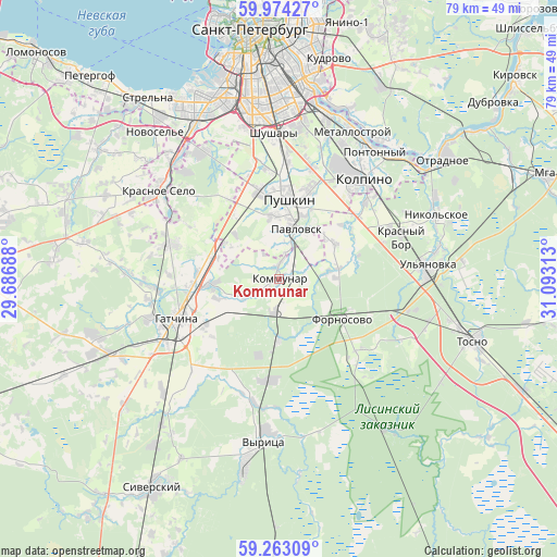
Kommunar GPS coordinates[2]
59° 37' 14.016" North, 30° 23' 24" East
| Map corner | latitude | longitude |
|---|---|---|
| Upper-left | 59.97427°, | 29.68688° |
| Center: | 59.62056°, | 30.39° |
| Lower-right: | 59.26309°, | 31.09313° |
| Map W x H: | 79.1×79.1 km | = 49.2×49.2mi |
| max Lat: | 73.50819° ⇑11.8% North |
| Kommunar: | 59.62056° |
| min Lat: | ⇓88.2% South 41.28413° |
| min Long | Kommunar | max Long |
| -179.12198° | 30.39° | 179.35046° |
| W 4.4%⇐ | ⇒95.6% E |
Elevation
Elevation of Kommunar is 64 m = 210 ft, and this is 138.6 m = 455 ft below average elevation for this country.
| Max E: |
2518 m = 8261 ft | 81.9% |
| Avg. | 202.6 m = 665 ft | |
| Kommunar | 64 m = 210 ft | |
Min E: |
-28 m = -92 ft | 18.1% |
See also: Russia elevation on elevation.city.
Geographical zone
Kommunar is located in North temperate zone (between Tropic of Cancer and the Arctic Circle). Distance of this North polar circle is 772 km =479.7 mi to North.| Distance of | km | miles | from Kommunar |
|---|---|---|---|
| North Pole | 3377.9 | 2098.9 | to North |
| Arctic Circle | 772 | 479.7 | to North |
| Tropic Cancer | 4023.3 | 2500 | to South |
| Equator | 6629.2 | 4119.2 | to South |


Nearby cities:
15 places around Kommunar: (largest is in red/bold)
• Aleksandrovskaya
12.7 km =7.9 mi,  345°
345°
• Fornosovo
10.9 km =6.8 mi,  121°
121°
• Fëdorovskoye
9.3 km =5.8 mi,  59°
59°
• Gatchina
15.5 km =9.6 mi,  251°
251°
• Kolpino
18.3 km =11.4 mi,  37°
37°
• Krasnyy Bor
17 km =10.6 mi,  66°
66°
• Maloye Verevo
12.2 km =7.6 mi,  266°
266°
• Mariyenburg
19.1 km =11.9 mi, 253°
• Pavlovsk
7.4 km =4.6 mi,  19°
19°
• Petro-Slavyanka
21.2 km =13.2 mi, 17°
• Pushkin
10.4 km =6.5 mi,  1°
1°
• Shushary
21 km =13 mi,  358°
358°
• Taytsy
16.2 km =10.1 mi,  287°
287°
• Tyarlevo
10.2 km =6.3 mi, 17°
• Ul’yanovka
21.2 km =13.2 mi,  84°
84°
Sources, notices
• [Note1] Compared only with cities in Russia existing in our database
• [Src1] Map data: © OpenStreetMap contributors (CC-BY-SA)
• [Src2] Other city data from geonames.org with taken over terms of usage.
• [Src3] Geographical zone / Annual Mean Temperature by Robert A. Rohde @ Wikipedia
