Kokhma geodata
Kokhma (Ivanovo) is a populated place; located in Russia in Europe/Moscow (GMT+3) time zone. With population of 28,984 people, there are 678 cities with bigger population in this country. Compared to other cities in Russia, 76.7% of cities are located further ↓South; 62.8% of cities are located further →East and 62% of cities have higher elevation than Kokhma. Note1


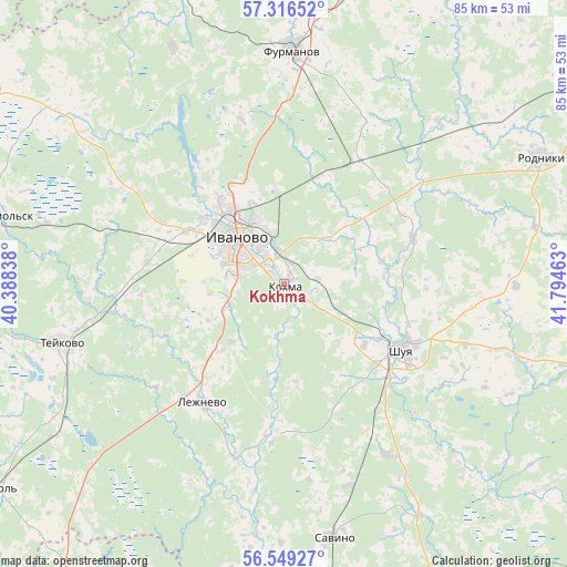
Kokhma GPS coordinates[2]
56° 56' 5.532" North, 41° 5' 29.4" East
| Map corner | latitude | longitude |
|---|---|---|
| Upper-left | 57.31652°, | 40.38838° |
| Center: | 56.93487°, | 41.0915° |
| Lower-right: | 56.54927°, | 41.79463° |
| Map W x H: | 85.3×85.3 km | = 53×53mi |
| max Lat: | 73.50819° ⇑23.3% North |
| Kokhma: | 56.93487° |
| min Lat: | ⇓76.7% South 41.28413° |
| min Long | Kokhma | max Long |
| -179.12198° | 41.0915° | 179.35046° |
| W 37.2%⇐ | ⇒62.8% E |
Elevation
Elevation of Kokhma is 120 m = 394 ft, and this is 82.6 m = 271 ft below average elevation for this country.
| Max E: |
2518 m = 8261 ft | 62% |
| Avg. | 202.6 m = 665 ft | |
| Kokhma | 120 m = 394 ft | |
Min E: |
-28 m = -92 ft | 38% |
See also: Russia elevation on elevation.city.
Geographical zone
Kokhma is located in North temperate zone (between Tropic of Cancer and the Arctic Circle). Distance of this North polar circle is 1070.6 km =665.2 mi to North.| Distance of | km | miles | from Kokhma |
|---|---|---|---|
| North Pole | 3676.5 | 2284.5 | to North |
| Arctic Circle | 1070.6 | 665.2 | to North |
| Tropic Cancer | 3724.6 | 2314.4 | to South |
| Equator | 6330.6 | 3933.7 | to South |


Nearby cities:
15 places around Kokhma: (largest is in red/bold)
• Arkhipovka
31.8 km =19.8 mi,  161°
161°
• Bogorodskoye
13.3 km =8.3 mi,  339°
339°
• Furmanov
35.5 km =22.1 mi,  1°
1°
• Ivanovo
10.1 km =6.3 mi,  313°
313°
• Kaminskiy
33.4 km =20.8 mi,  43°
43°
• Kitovo
13.9 km =8.6 mi,  123°
123°
• Kolobovo
30 km =18.6 mi,  149°
149°
• Lezhnevo
21.5 km =13.4 mi,  214°
214°
• Markovo
37.3 km =23.2 mi,  284°
284°
• Novo-Talitsy
16 km =9.9 mi,  298°
298°
• Novoye Leushino
37.8 km =23.5 mi,  247°
247°
• Novyye Gorki
23.4 km =14.5 mi,  184°
184°
• Savino
38.8 km =24.1 mi,  168°
168°
• Shuya
20.4 km =12.7 mi, 118°
• Teykovo
34.7 km =21.6 mi,  255°
255°
Sources, notices
• [Note1] Compared only with cities in Russia existing in our database
• [Src1] Map data: © OpenStreetMap contributors (CC-BY-SA)
• [Src2] Other city data from geonames.org with taken over terms of usage.
• [Src3] Geographical zone / Annual Mean Temperature by Robert A. Rohde @ Wikipedia
