Khamamatyurt geodata
Khamamatyurt (Dagestan) is a populated place; located in Russia in Europe/Moscow (GMT+3) time zone. With population of 4,935 people, there are 2696 cities with bigger population in this country. Compared to other cities in Russia, 93.5% of cities are located further ↑North; 54.2% of cities are located further ←West and 97.6% of cities have higher elevation than Khamamatyurt. Note1


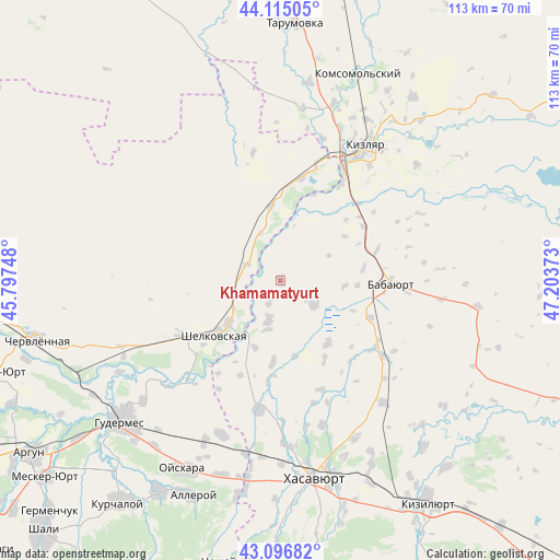
Khamamatyurt GPS coordinates[2]
43° 36' 29.124" North, 46° 30' 2.16" East
| Map corner | latitude | longitude |
|---|---|---|
| Upper-left | 44.11505°, | 45.79748° |
| Center: | 43.60809°, | 46.5006° |
| Lower-right: | 43.09682°, | 47.20373° |
| Map W x H: | 113.2×113.2 km | = 70.3×70.3mi |
| max Lat: | 73.50819° ⇑93.5% North |
| Khamamatyurt: | 43.60809° |
| min Lat: | ⇓6.5% South 41.28413° |
| min Long | Khamamatyurt | max Long |
| -179.12198° | 46.5006° | 179.35046° |
| W 54.2%⇐ | ⇒45.8% E |
Elevation
Elevation of Khamamatyurt is 6 m = 20 ft, and this is 196.6 m = 645 ft below average elevation for this country.
| Max E: |
2518 m = 8261 ft | 97.6% |
| Avg. | 202.6 m = 665 ft | |
| Khamamatyurt | 6 m = 20 ft | |
Min E: |
-28 m = -92 ft | 2.4% |
See also: Russia elevation on elevation.city.
Geographical zone
Khamamatyurt is located in North temperate zone (between Tropic of Cancer and the Arctic Circle). Distance of this Northern Tropic circle is 2242.8 km =1393.6 mi to South.| Distance of | km | miles | from Khamamatyurt |
|---|---|---|---|
| North Pole | 5158.3 | 3205.2 | to North |
| Arctic Circle | 2552.4 | 1586 | to North |
| Tropic Cancer | 2242.8 | 1393.6 | to South |
| Equator | 4848.8 | 3012.9 | to South |


Nearby cities:
15 places around Khamamatyurt: (largest is in red/bold)
• Adil’-Yangiyurt
8.4 km =5.2 mi,  126°
126°
• Aksay
26.6 km =16.5 mi,  189°
189°
• Babayurt
22.4 km =13.9 mi,  92°
92°
• Bammatyurt
30.4 km =18.9 mi,  163°
163°
• Botashyurt
33.4 km =20.8 mi,  178°
178°
• Botayurt
35.4 km =22 mi, 155°
• Engel’-Yurt
33.3 km =20.7 mi,  199°
199°
• Grebenskaya
13.5 km =8.4 mi,  230°
230°
• Kargalinskaya
15.2 km =9.4 mi,  353°
353°
• Kizlyar
31.6 km =19.6 mi,  32°
32°
• Novogagatli
16.9 km =10.5 mi, 185°
• Nuradilovo
36.1 km =22.4 mi, 185°
• Shëlkovskaya
17.1 km =10.6 mi, 229°
• Solnechnoye
36.9 km =22.9 mi, 179°
• Utsmiyurt
8.5 km =5.3 mi, 197°
Sources, notices
• [Note1] Compared only with cities in Russia existing in our database
• [Src1] Map data: © OpenStreetMap contributors (CC-BY-SA)
• [Src2] Other city data from geonames.org with taken over terms of usage.
• [Src3] Geographical zone / Annual Mean Temperature by Robert A. Rohde @ Wikipedia
