Kamenskiy Khutor geodata
Kamenskiy Khutor (Bryansk Oblast) is a populated place; located in Russia in Europe/Moscow (GMT+3) time zone. With population of 575 people, there are 4913 cities with bigger population in this country. Compared to other cities in Russia, 68.4% of cities are located further ↑North; 93.1% of cities are located further →East and 51.6% of cities have higher elevation than Kamenskiy Khutor. Note1


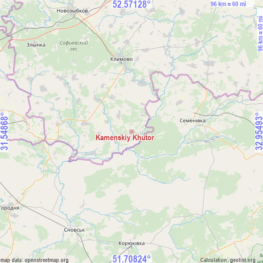
Kamenskiy Khutor GPS coordinates[2]
52° 8' 30.66" North, 32° 15' 6.48" East
| Map corner | latitude | longitude |
|---|---|---|
| Upper-left | 52.57128°, | 31.54868° |
| Center: | 52.14185°, | 32.2518° |
| Lower-right: | 51.70824°, | 32.95493° |
| Map W x H: | 96×96 km | = 59.7×59.7mi |
| max Lat: | 73.50819° ⇑68.4% North |
| Kamenskiy Khutor: | 52.14185° |
| min Lat: | ⇓31.6% South 41.28413° |
| min Long | Kamenskiy Khuto | max Long |
| -179.12198° | 32.2518° | 179.35046° |
| W 6.9%⇐ | ⇒93.1% E |
Elevation
Elevation of Kamenskiy Khutor is 141 m = 463 ft, and this is 61.6 m = 202 ft below average elevation for this country.
| Max E: |
2518 m = 8261 ft | 51.6% |
| Avg. | 202.6 m = 665 ft | |
| Kamenskiy Khutor | 141 m = 463 ft | |
Min E: |
-28 m = -92 ft | 48.4% |
See also: Russia elevation on elevation.city.
Geographical zone
Kamenskiy Khutor is located in North temperate zone (between Tropic of Cancer and the Arctic Circle). Distance of this North polar circle is 1603.5 km =996.4 mi to North.| Distance of | km | miles | from Kamenskiy Khutor |
|---|---|---|---|
| North Pole | 4209.4 | 2615.6 | to North |
| Arctic Circle | 1603.5 | 996.4 | to North |
| Tropic Cancer | 3191.7 | 1983.2 | to South |
| Equator | 5797.6 | 3602.5 | to South |


Nearby cities:
15 places around Kamenskiy Khutor: (largest is in red/bold)
• Churovichi
17.9 km =11.1 mi,  279°
279°
• Deniskovichi
41.5 km =25.8 mi,  296°
296°
• Gulevka
52.1 km =32.4 mi,  358°
358°
• Khoromnoye
16.4 km =10.2 mi,  240°
240°
• Kivai
51.9 km =32.2 mi,  8°
8°
• Klimovo
26.8 km =16.7 mi,  351°
351°
• Novozybkov
49.4 km =30.7 mi,  333°
333°
• Novyy Ropsk
17.8 km =11.1 mi, 13°
• Sachkovichi
22.8 km =14.2 mi, 355°
• Shelomy
55.2 km =34.3 mi, 330°
• Snovskoye
40.5 km =25.2 mi,  341°
341°
• Trostan’
45.6 km =28.3 mi, 339°
• Vyshkov
53.4 km =33.2 mi,  314°
314°
• Zamishevo
47.1 km =29.3 mi, 339°
• Zlynka
47.2 km =29.3 mi, 312°
Sources, notices
• [Note1] Compared only with cities in Russia existing in our database
• [Src1] Map data: © OpenStreetMap contributors (CC-BY-SA)
• [Src2] Other city data from geonames.org with taken over terms of usage.
• [Src3] Geographical zone / Annual Mean Temperature by Robert A. Rohde @ Wikipedia
