Cherneya geodata
Cherneya (Pskov Oblast) is a seat of a third-order administrative division; located in Russia in Europe/Moscow (GMT+3) time zone. In our database, there are 4966 cities with bigger population. Compared to other cities in Russia, 69.9% of cities are located further ↓South; 98.7% of cities are located further →East and 51.1% of cities have higher elevation than Cherneya. Note1


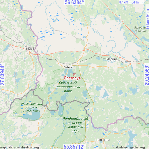
Cherneya GPS coordinates[2]
56° 14' 59.1" North, 28° 32' 33.216" East
| Map corner | latitude | longitude |
|---|---|---|
| Upper-left | 56.6384°, | 27.83944° |
| Center: | 56.24975°, | 28.54256° |
| Lower-right: | 55.85712°, | 29.24569° |
| Map W x H: | 86.9×86.9 km | = 54×54mi |
| max Lat: | 73.50819° ⇑30.1% North |
| Cherneya: | 56.24975° |
| min Lat: | ⇓69.9% South 41.28413° |
| min Long | Cherneya | max Long |
| -179.12198° | 28.54256° | 179.35046° |
| W 1.3%⇐ | ⇒98.7% E |
Elevation
Elevation of Cherneya is 142 m = 466 ft, and this is 60.6 m = 199 ft below average elevation for this country.
| Max E: |
2518 m = 8261 ft | 51.1% |
| Avg. | 202.6 m = 665 ft | |
| Cherneya | 142 m = 466 ft | |
Min E: |
-28 m = -92 ft | 48.9% |
See also: Russia elevation on elevation.city.
Geographical zone
Cherneya is located in North temperate zone (between Tropic of Cancer and the Arctic Circle). Distance of this North polar circle is 1146.8 km =712.6 mi to North.| Distance of | km | miles | from Cherneya |
|---|---|---|---|
| North Pole | 3752.7 | 2331.8 | to North |
| Arctic Circle | 1146.8 | 712.6 | to North |
| Tropic Cancer | 3648.5 | 2267.1 | to South |
| Equator | 6254.4 | 3886.3 | to South |


Nearby cities:
15 places around Cherneya: (largest is in red/bold)
• Dedino
18 km =11.2 mi,  268°
268°
• Dubrovka
16.8 km =10.4 mi,  20°
20°
• Glembochino
12.3 km =7.6 mi,  235°
235°
• Glubokoye
49.6 km =30.8 mi,  36°
36°
• Idritsa
23.8 km =14.8 mi,  67°
67°
• Makushino
48.9 km =30.4 mi,  354°
354°
• Mostishche
14.4 km =8.9 mi, 71°
• Osyno
13.8 km =8.6 mi,  143°
143°
• Petrovskoye
50.2 km =31.2 mi,  7°
7°
• Pokrovskoye
52 km =32.3 mi,  340°
340°
• Pustoshka
51.9 km =32.2 mi,  79°
79°
• Sebezh
5.4 km =3.4 mi,  316°
316°
• Tomsino
22.5 km =14 mi,  359°
359°
• Zanogi
40.2 km =25 mi, 39°
• Zvony
44.9 km =27.9 mi, 21°
Sources, notices
• [Note1] Compared only with cities in Russia existing in our database
• [Src1] Map data: © OpenStreetMap contributors (CC-BY-SA)
• [Src2] Other city data from geonames.org with taken over terms of usage.
• [Src3] Geographical zone / Annual Mean Temperature by Robert A. Rohde @ Wikipedia
