Bagrationovsk geodata
Bagrationovsk (Kaliningrad) is a seat of a second-order administrative division; located in Russia in Europe/Kaliningrad (GMT+2) time zone. With population of 7,306 people, there are 1930 cities with bigger population in this country. Compared to other cities in Russia, 52.1% of cities are located further ↑North; 99.5% of cities are located further →East and 79.6% of cities have higher elevation than Bagrationovsk. Note1


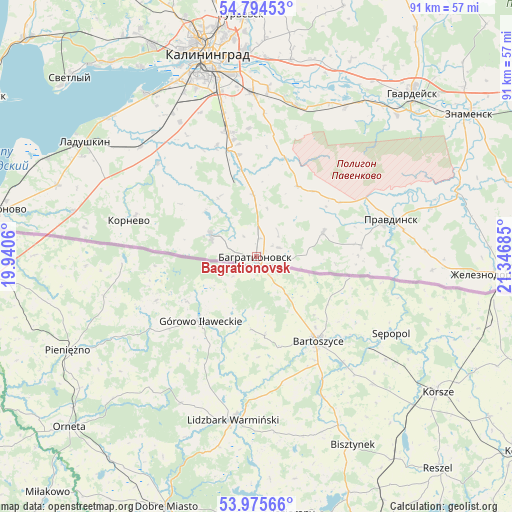
Bagrationovsk GPS coordinates[2]
54° 23' 13.704" North, 20° 38' 37.392" East
| Map corner | latitude | longitude |
|---|---|---|
| Upper-left | 54.79453°, | 19.9406° |
| Center: | 54.38714°, | 20.64372° |
| Lower-right: | 53.97566°, | 21.34685° |
| Map W x H: | 91×91 km | = 56.5×56.5mi |
| max Lat: | 73.50819° ⇑52.1% North |
| Bagrationovsk: | 54.38714° |
| min Lat: | ⇓47.9% South 41.28413° |
| min Long | Bagrationovsk | max Long |
| -179.12198° | 20.64372° | 179.35046° |
| W 0.5%⇐ | ⇒99.5% E |
Elevation
Elevation of Bagrationovsk is 72 m = 236 ft, and this is 130.6 m = 428 ft below average elevation for this country.
| Max E: |
2518 m = 8261 ft | 79.6% |
| Avg. | 202.6 m = 665 ft | |
| Bagrationovsk | 72 m = 236 ft | |
Min E: |
-28 m = -92 ft | 20.4% |
See also: Russia elevation on elevation.city.
Geographical zone
Bagrationovsk is located in North temperate zone (between Tropic of Cancer and the Arctic Circle). Distance of this North polar circle is 1353.9 km =841.3 mi to North.| Distance of | km | miles | from Bagrationovsk |
|---|---|---|---|
| North Pole | 3959.8 | 2460.5 | to North |
| Arctic Circle | 1353.9 | 841.3 | to North |
| Tropic Cancer | 3441.4 | 2138.4 | to South |
| Equator | 6047.3 | 3757.6 | to South |


Nearby cities:
15 places around Bagrationovsk: (largest is in red/bold)
• Bol'shoe Isakovo
36.9 km =22.9 mi,  355°
355°
• Gur’yevsk
43 km =26.7 mi, 356°
• Gvardeysk
39.7 km =24.7 mi,  43°
43°
• Kaliningrad
36.5 km =22.7 mi,  346°
346°
• Ladushkin
36.7 km =22.8 mi,  303°
303°
• Maloye Isakovo
38.6 km =24 mi, 354°
• Mamonovo
46.4 km =28.8 mi,  280°
280°
• Nizov’ye
35.5 km =22.1 mi,  9°
9°
• Pravdinsk
25 km =15.5 mi,  75°
75°
• Svetlyy
45.9 km =28.5 mi,  314°
314°
• Volochayevskoye
44.3 km =27.5 mi,  321°
321°
• Vzmorye
43.3 km =26.9 mi, 322°
• Yuzhnyy
18.2 km =11.3 mi, 350°
• Zheleznodorozhnyy
43 km =26.7 mi,  94°
94°
• Znamensk
45.3 km =28.1 mi,  56°
56°
Sources, notices
• [Note1] Compared only with cities in Russia existing in our database
• [Src1] Map data: © OpenStreetMap contributors (CC-BY-SA)
• [Src2] Other city data from geonames.org with taken over terms of usage.
• [Src3] Geographical zone / Annual Mean Temperature by Robert A. Rohde @ Wikipedia
