Polysayevo geodata
Polysayevo (Kemerovo Oblast) is a populated place; located in Russia in Asia/Novokuznetsk (GMT+7) time zone. With population of 28,026 people, there are 698 cities with bigger population in this country. Compared to other cities in Russia, 50.4% of cities are located further ↑North; 84% of cities are located further ←West and 75% of cities have lower elevation than Polysayevo. Note1


Polysayevo GPS coordinates[2]
54° 36' 4.32" North, 86° 14' 45.24" East
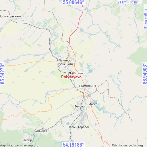
| Map corner | latitude | longitude |
|---|---|---|
| Upper-left | 55.00646°, | 85.54278° |
| Center: | 54.6012°, | 86.2459° |
| Lower-right: | 54.19186°, | 86.94903° |
| Map W x H: | 90.6×90.6 km | = 56.3×56.3mi |
| max Lat: | 73.50819° ⇑50.4% North |
| Polysayevo: | 54.6012° |
| min Lat: | ⇓49.6% South 41.28413° |
| min Long | Polysayevo | max Long |
| -179.12198° | 86.2459° | 179.35046° |
| W 84%⇐ | ⇒16% E |
Elevation
Elevation of Polysayevo is 217 m = 712 ft, and this is 14.4 m = 47 ft above average elevation for this country.
| Max E: |
2518 m = 8261 ft | 25% |
| Polysayevo | 217 m 712 ft | |
| Avg. | 202.6 m = 665 ft | |
Min E: |
-28 m = -92 ft | 75% |
See also: Russia elevation on elevation.city.
Geographical zone
Polysayevo is located in North temperate zone (between Tropic of Cancer and the Arctic Circle). Distance of this North polar circle is 1330.1 km =826.5 mi to North.| Distance of | km | miles | from Polysayevo |
|---|---|---|---|
| North Pole | 3936 | 2445.7 | to North |
| Arctic Circle | 1330.1 | 826.5 | to North |
| Tropic Cancer | 3465.2 | 2153.2 | to South |
| Equator | 6071.1 | 3772.4 | to South |


Nearby cities:
15 places around Polysayevo: (largest is in red/bold)
• Bachatskiy
35.1 km =21.8 mi,  192°
192°
• Belovo
20.8 km =12.9 mi,  170°
170°
• Gorskino
42.6 km =26.5 mi,  249°
249°
• Gramoteino
11.4 km =7.1 mi,  128°
128°
• Gur’yevsk
40.7 km =25.3 mi,  209°
209°
• Inskoy
22.8 km =14.2 mi,  146°
146°
• Krasnobrodskiy
51 km =31.7 mi, 165°
• Krasnogorskiy
6.4 km =4 mi,  159°
159°
• Leninsk-Kuznetsky
7.7 km =4.8 mi,  323°
323°
• Nikitinskiy
15.2 km =9.4 mi,  262°
262°
• Novopesterevo
37.1 km =23.1 mi,  241°
241°
• Plotnikovo
50.9 km =31.6 mi,  337°
337°
• Salair
50.4 km =31.3 mi,  215°
215°
• Starobachaty
40 km =24.9 mi,  183°
183°
• Staropesterevo
15.4 km =9.6 mi,  136°
136°
Sources, notices
• [Note1] Compared only with cities in Russia existing in our database
• [Src1] Map data: © OpenStreetMap contributors (CC-BY-SA)
• [Src2] Other city data from geonames.org with taken over terms of usage.
• [Src3] Geographical zone / Annual Mean Temperature by Robert A. Rohde @ Wikipedia
