Tulagi geodata
Tulagi (Central Province) is a seat of a first-order administrative division; located in Solomon Islands in Pacific/Guadalcanal (GMT+11) time zone. With population of 1,750 people, there are 4 cities with bigger population in this country. Compared to other cities in Solomon Islands, 57.1% of cities are located further ↑North; 57.1% of cities are located further ←West and 100% of cities have higher elevation than Tulagi. Note1


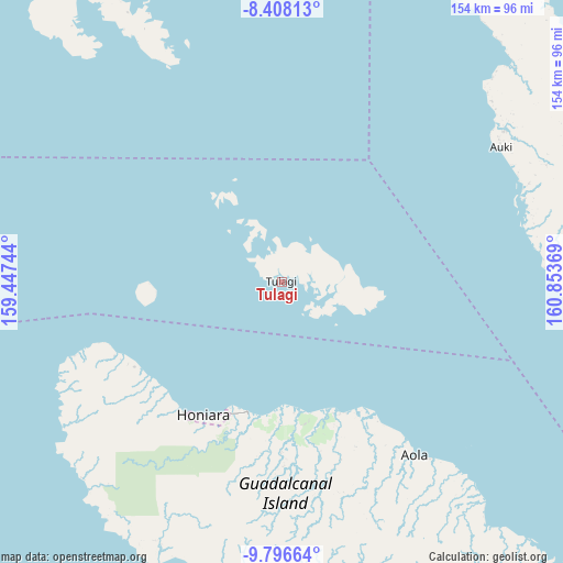
Tulagi GPS coordinates[2]
9° 6' 11.016" South, 160° 9' 2.016" East
| Map corner | latitude | longitude |
|---|---|---|
| Upper-left | -8.40813°, | 159.44744° |
| Center: | -9.10306°, | 160.15056° |
| Lower-right: | -9.79664°, | 160.85369° |
| Map W x H: | 154.4×154.4 km | = 95.9×95.9mi |
| max Lat: | -6.71111° ⇑57.1% North |
| Tulagi: | -9.10306° |
| min Lat: | ⇓42.9% South -10.725° |
| min Long | Tulagi | max Long |
| 156.39722° | 160.15056° | 165.79722° |
| W 57.1%⇐ | ⇒42.9% E |
Elevation
Elevation of Tulagi is 0 m = 0 ft, and this is 15 m = 49 ft below average elevation for this country.
| Max E: |
49 m = 161 ft | 100% |
| Avg. | 15 m = 49 ft | |
| Tulagi | 0 m = 0 ft | |
Min E: |
0 m = 0 ft | 0% |
See also: Solomon Islands elevation on elevation.city.
Geographical zone
Tulagi is located in South Torrid zone (between Equator and Tropic of Capricorn). Distance of Equator is 1012.2 km =629 mi to North.| Distance of | km | miles | from Tulagi |
|---|---|---|---|
| Equator | 1012.2 | 629 | to North |
| Tropic Capricorn | 1593.8 | 990.3 | to South |
| Antarctic Circle | 6389 | 3969.9 | to South |
| South Pole | 8994.9 | 5589.2 | to South |


Nearby cities:
5 places around Tulagi: (largest is in red/bold)
• Auki
70.7 km =43.9 mi,  58°
58°
• Buala
123 km =76.4 mi,  330°
330°
• Gizo
380.4 km =236.4 mi,  286°
286°
• Honiara
42.8 km =26.6 mi,  210°
210°
• Kirakira
245.3 km =152.4 mi,  127°
127°
Sources, notices
• [Note1] Compared only with cities in Solomon Islands existing in our database
• [Src1] Map data: © OpenStreetMap contributors (CC-BY-SA)
• [Src2] Other city data from geonames.org with taken over terms of usage.
• [Src3] Geographical zone / Annual Mean Temperature by Robert A. Rohde @ Wikipedia
