Taro geodata
Taro (Choiseul) is a seat of a first-order administrative division; located in Solomon Islands in Pacific/Guadalcanal (GMT+11) time zone. In our database, there are 7 cities with bigger population. Compared to other cities in Solomon Islands, 100% of cities are located further ↓South; 100% of cities are located further →East and 100% of cities have higher elevation than Taro. Note1


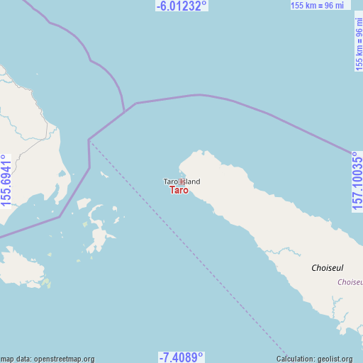
Taro GPS coordinates[2]
6° 42' 39.996" South, 156° 23' 49.992" East
| Map corner | latitude | longitude |
|---|---|---|
| Upper-left | -6.01232°, | 155.6941° |
| Center: | -6.71111°, | 156.39722° |
| Lower-right: | -7.4089°, | 157.10035° |
| Map W x H: | 155.3×155.3 km | = 96.5×96.5mi |
| max Lat: | -6.71111° ⇑0% North |
| Taro: | -6.71111° |
| min Lat: | ⇓100% South -10.725° |
| min Long | Taro | max Long |
| 156.39722° | 156.39722° | 165.79722° |
| W 0%⇐ | ⇒100% E |
Elevation
Elevation of Taro is 0 m = 0 ft, and this is 15 m = 49 ft below average elevation for this country.
| Max E: |
49 m = 161 ft | 100% |
| Avg. | 15 m = 49 ft | |
| Taro | 0 m = 0 ft | |
Min E: |
0 m = 0 ft | 0% |
See also: Solomon Islands elevation on elevation.city.
Geographical zone
Taro is located in South Torrid zone (between Equator and Tropic of Capricorn). Distance of Equator is 746.2 km =463.7 mi to North.| Distance of | km | miles | from Taro |
|---|---|---|---|
| Equator | 746.2 | 463.7 | to North |
| Tropic Capricorn | 1859.7 | 1155.6 | to South |
| Antarctic Circle | 6655 | 4135.2 | to South |
| South Pole | 9260.9 | 5754.5 | to South |


Nearby cities:
2 places around Taro: (largest is in red/bold)
• Buala
386.6 km =240.2 mi,  114°
114°
• Gizo
162.3 km =100.8 mi,  162°
162°
Sources, notices
• [Note1] Compared only with cities in Solomon Islands existing in our database
• [Src1] Map data: © OpenStreetMap contributors (CC-BY-SA)
• [Src2] Other city data from geonames.org with taken over terms of usage.
• [Src3] Geographical zone / Annual Mean Temperature by Robert A. Rohde @ Wikipedia
