Staffanstorp geodata
Staffanstorp (Skåne) is a seat of a second-order administrative division; located in Sweden in Europe/Stockholm (GMT+2) time zone. With population of 15,373 people, there are 103 cities with bigger population in this country. Compared to other cities in Sweden, 96.6% of cities are located further ↑North; 75.4% of cities are located further →East and 78.5% of cities have higher elevation than Staffanstorp. Note1


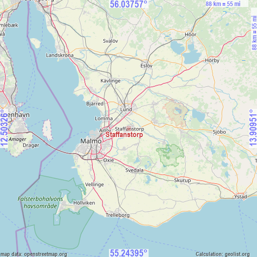
Staffanstorp GPS coordinates[2]
55° 38' 33.972" North, 13° 12' 22.968" East
| Map corner | latitude | longitude |
|---|---|---|
| Upper-left | 56.03757°, | 12.50326° |
| Center: | 55.64277°, | 13.20638° |
| Lower-right: | 55.24395°, | 13.90951° |
| Map W x H: | 88.2×88.2 km | = 54.8×54.8mi |
| max Lat: | 67.85572° ⇑96.6% North |
| Staffanstorp: | 55.64277° |
| min Lat: | ⇓3.4% South 55.34337° |
| min Long | Staffanstorp | max Long |
| 11.1712° | 13.20638° | 24.13676° |
| W 24.6%⇐ | ⇒75.4% E |
Elevation
Elevation of Staffanstorp is 17 m = 56 ft, and this is 65.6 m = 215 ft below average elevation for this country.
| Max E: |
663 m = 2175 ft | 78.5% |
| Avg. | 82.6 m = 271 ft | |
| Staffanstorp | 17 m = 56 ft | |
Min E: |
-1 m = -3 ft | 21.5% |
See also: Sweden elevation on elevation.city.
Geographical zone
Staffanstorp is located in North temperate zone (between Tropic of Cancer and the Arctic Circle). Distance of this North polar circle is 1214.3 km =754.5 mi to North.| Distance of | km | miles | from Staffanstorp |
|---|---|---|---|
| North Pole | 3820.2 | 2373.8 | to North |
| Arctic Circle | 1214.3 | 754.5 | to North |
| Tropic Cancer | 3581 | 2225.1 | to South |
| Equator | 6186.9 | 3844.4 | to South |


Nearby cities:
15 places around Staffanstorp: (largest is in red/bold)
• Arlöv
8.5 km =5.3 mi,  262°
262°
• Bara
7 km =4.3 mi,  194°
194°
• Bjärred
14.5 km =9 mi,  304°
304°
• Dalby
9.4 km =5.8 mi,  73°
73°
• Genarp
13 km =8.1 mi,  111°
111°
• Hjärup
5.1 km =3.2 mi, 304°
• Klågerup
5.9 km =3.7 mi,  155°
155°
• Lomma
9.3 km =5.8 mi,  290°
290°
• Lund
7.1 km =4.4 mi,  353°
353°
• Malmö
13.5 km =8.4 mi,  252°
252°
• Oxie
13.4 km =8.3 mi,  211°
211°
• Stångby
12 km =7.5 mi,  357°
357°
• Svedala
15.1 km =9.4 mi,  173°
173°
• Södra Sandby
12 km =7.5 mi,  46°
46°
• Åkarp
6.1 km =3.8 mi,  281°
281°
Sources, notices
• [Note1] Compared only with cities in Sweden existing in our database
• [Src1] Map data: © OpenStreetMap contributors (CC-BY-SA)
• [Src2] Other city data from geonames.org with taken over terms of usage.
• [Src3] Geographical zone / Annual Mean Temperature by Robert A. Rohde @ Wikipedia
