Kvisljungeby geodata
Kvisljungeby (Västra Götaland) is a populated place; located in Sweden in Europe/Stockholm (GMT+2) time zone. With population of 586 people, there are 1191 cities with bigger population in this country. Compared to other cities in Sweden, 65.8% of cities are located further ↑North; 96.5% of cities are located further →East and 73.7% of cities have higher elevation than Kvisljungeby. Note1


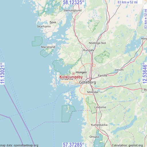
Kvisljungeby GPS coordinates[2]
57° 45' 0" North, 11° 49' 59.988" East
| Map corner | latitude | longitude |
|---|---|---|
| Upper-left | 58.12325°, | 11.13021° |
| Center: | 57.75°, | 11.83333° |
| Lower-right: | 57.37285°, | 12.53646° |
| Map W x H: | 83.4×83.4 km | = 51.8×51.8mi |
| max Lat: | 67.85572° ⇑65.8% North |
| Kvisljungeby: | 57.75° |
| min Lat: | ⇓34.2% South 55.34337° |
| min Long | Kvisljungeby | max Long |
| 11.1712° | 11.83333° | 24.13676° |
| W 3.5%⇐ | ⇒96.5% E |
Elevation
Elevation of Kvisljungeby is 21 m = 69 ft, and this is 61.6 m = 202 ft below average elevation for this country.
| Max E: |
663 m = 2175 ft | 73.7% |
| Avg. | 82.6 m = 271 ft | |
| Kvisljungeby | 21 m = 69 ft | |
Min E: |
-1 m = -3 ft | 26.3% |
See also: Sweden elevation on elevation.city.
Geographical zone
Kvisljungeby is located in North temperate zone (between Tropic of Cancer and the Arctic Circle). Distance of this North polar circle is 980 km =608.9 mi to North.| Distance of | km | miles | from Kvisljungeby |
|---|---|---|---|
| North Pole | 3585.9 | 2228.2 | to North |
| Arctic Circle | 980 | 608.9 | to North |
| Tropic Cancer | 3815.3 | 2370.7 | to South |
| Equator | 6421.2 | 3989.9 | to South |


Nearby cities:
15 places around Kvisljungeby: (largest is in red/bold)
• Andalen
7 km =4.3 mi,  217°
217°
• Björkö
9.4 km =5.8 mi,  257°
257°
• Björlanda
1.9 km =1.2 mi,  0°
0°
• Brännö
12 km =7.5 mi,  194°
194°
• Göteborg
9.2 km =5.7 mi,  121°
121°
• Hjuvik
8.8 km =5.5 mi,  232°
232°
• Hälsö
10.5 km =6.5 mi, 260°
• Kyrkobyn
7.4 km =4.6 mi,  41°
41°
• Kärna
11.5 km =7.1 mi,  345°
345°
• Majorna
8.1 km =5 mi,  142°
142°
• Nolvik
2.8 km =1.7 mi, 0°
• Nolvik
3.8 km =2.4 mi, 345°
• Torslanda
4.7 km =2.9 mi, 232°
• Tumlehed
6 km =3.7 mi,  250°
250°
• Öckerö
11.5 km =7.1 mi, 246°
Sources, notices
• [Note1] Compared only with cities in Sweden existing in our database
• [Src1] Map data: © OpenStreetMap contributors (CC-BY-SA)
• [Src2] Other city data from geonames.org with taken over terms of usage.
• [Src3] Geographical zone / Annual Mean Temperature by Robert A. Rohde @ Wikipedia
