Donsö geodata
Donsö (Västra Götaland) is a populated place; located in Sweden in Europe/Stockholm (GMT+2) time zone. With population of 1,446 people, there are 673 cities with bigger population in this country. Compared to other cities in Sweden, 70.4% of cities are located further ↑North; 97% of cities are located further →East and 85.7% of cities have higher elevation than Donsö. Note1


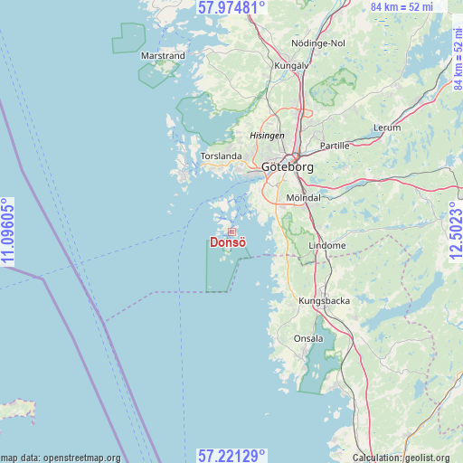
Donsö GPS coordinates[2]
57° 36' 0" North, 11° 47' 57.012" East
| Map corner | latitude | longitude |
|---|---|---|
| Upper-left | 57.97481°, | 11.09605° |
| Center: | 57.6°, | 11.79917° |
| Lower-right: | 57.22129°, | 12.5023° |
| Map W x H: | 83.8×83.8 km | = 52.1×52.1mi |
| max Lat: | 67.85572° ⇑70.4% North |
| Donsö: | 57.6° |
| min Lat: | ⇓29.6% South 55.34337° |
| min Long | Donsö | max Long |
| 11.1712° | 11.79917° | 24.13676° |
| W 3%⇐ | ⇒97% E |
Elevation
Elevation of Donsö is 12 m = 39 ft, and this is 70.6 m = 232 ft below average elevation for this country.
| Max E: |
663 m = 2175 ft | 85.7% |
| Avg. | 82.6 m = 271 ft | |
| Donsö | 12 m = 39 ft | |
Min E: |
-1 m = -3 ft | 14.3% |
See also: Sweden elevation on elevation.city.
Geographical zone
Donsö is located in North temperate zone (between Tropic of Cancer and the Arctic Circle). Distance of this North polar circle is 996.7 km =619.3 mi to North.| Distance of | km | miles | from Donsö |
|---|---|---|---|
| North Pole | 3602.5 | 2238.5 | to North |
| Arctic Circle | 996.7 | 619.3 | to North |
| Tropic Cancer | 3798.6 | 2360.3 | to South |
| Equator | 6404.5 | 3979.6 | to South |


Nearby cities:
15 places around Donsö: (largest is in red/bold)
• Andalen
11.4 km =7.1 mi,  348°
348°
• Billdal
8.8 km =5.5 mi,  114°
114°
• Brännö
5.1 km =3.2 mi, 348°
• Fotö
11.2 km =7 mi,  311°
311°
• Hjuvik
12.3 km =7.6 mi,  336°
336°
• Hönö
13.4 km =8.3 mi,  318°
318°
• Kållered
15 km =9.3 mi,  85°
85°
• Majorna
12.4 km =7.7 mi,  34°
34°
• Mölndal
14.2 km =8.8 mi,  64°
64°
• Styrsö
2 km =1.2 mi, 336°
• Särö
13.1 km =8.1 mi,  142°
142°
• Torslanda
13.9 km =8.6 mi, 352°
• Tumlehed
15.2 km =9.4 mi, 346°
• Västra Frölunda
9.3 km =5.8 mi, 56°
• Öckerö
14.7 km =9.1 mi, 324°
Sources, notices
• [Note1] Compared only with cities in Sweden existing in our database
• [Src1] Map data: © OpenStreetMap contributors (CC-BY-SA)
• [Src2] Other city data from geonames.org with taken over terms of usage.
• [Src3] Geographical zone / Annual Mean Temperature by Robert A. Rohde @ Wikipedia
