Stanežiče geodata
Stanežiče (Ljubljana) is a populated place; located in Slovenia in Europe/Ljubljana (GMT+2) time zone. With population of 716 people, there are 349 cities with bigger population in this country. Compared to other cities in Slovenia, 67.7% of cities are located further ↑North; 68.2% of cities are located further →East and 64.8% of cities have lower elevation than Stanežiče. Note1


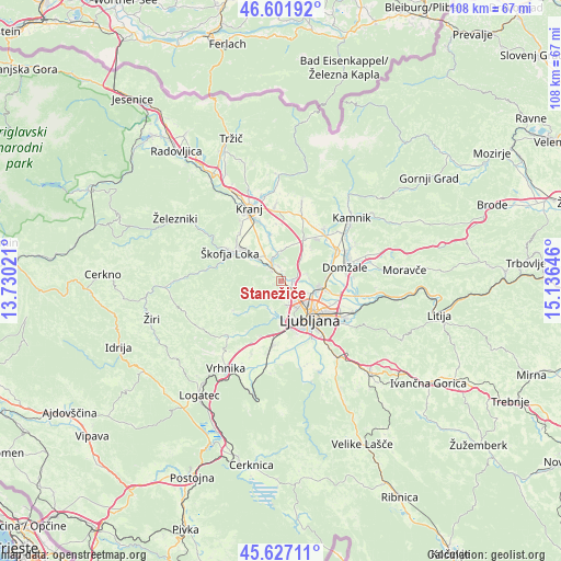
Stanežiče GPS coordinates[2]
46° 7' 0.012" North, 14° 25' 59.988" East
| Map corner | latitude | longitude |
|---|---|---|
| Upper-left | 46.60192°, | 13.73021° |
| Center: | 46.11667°, | 14.43333° |
| Lower-right: | 45.62711°, | 15.13646° |
| Map W x H: | 108.4×108.4 km | = 67.4×67.4mi |
| max Lat: | 46.83694° ⇑67.7% North |
| Stanežiče: | 46.11667° |
| min Lat: | ⇓32.3% South 45.47667° |
| min Long | Stanežiče | max Long |
| 13.52639° | 14.43333° | 16.4975° |
| W 31.8%⇐ | ⇒68.2% E |
Elevation
Elevation of Stanežiče is 346 m = 1135 ft, and this is 20.4 m = 67 ft above average elevation for this country.
| Max E: |
1551 m = 5089 ft | 35.2% |
| Stanežiče | 346 m 1135 ft | |
| Avg. | 325.6 m = 1068 ft | |
Min E: |
2 m = 7 ft | 64.8% |
See also: Slovenia elevation on elevation.city.
Geographical zone
Stanežiče is located in North temperate zone (between Tropic of Cancer and the Arctic Circle). Distance of this North polar circle is 2273.5 km =1412.7 mi to North.| Distance of | km | miles | from Stanežiče |
|---|---|---|---|
| North Pole | 4879.4 | 3031.9 | to North |
| Arctic Circle | 2273.5 | 1412.7 | to North |
| Tropic Cancer | 2521.8 | 1567 | to South |
| Equator | 5127.7 | 3186.2 | to South |


Nearby cities:
15 places around Stanežiče: (largest is in red/bold)
• Dobrova
8.5 km =5.3 mi,  202°
202°
• Godešič
8.2 km =5.1 mi,  312°
312°
• Goričane
4 km =2.5 mi, 309°
• Medvode
3.3 km =2.1 mi,  328°
328°
• Podreča
6.4 km =4 mi,  345°
345°
• Reteče
7 km =4.3 mi, 313°
• Spodnje Gameljne
5.1 km =3.2 mi,  90°
90°
• Spodnje Pirniče
2 km =1.2 mi,  11°
11°
• Srednje Gameljne
5.7 km =3.5 mi,  75°
75°
• Valburga
5.6 km =3.5 mi,  0°
0°
• Vaše
3.5 km =2.2 mi,  303°
303°
• Verje
3.6 km =2.2 mi,  341°
341°
• Zbilje
5.7 km =3.5 mi, 347°
• Zgornje Pirniče
2.9 km =1.8 mi,  357°
357°
• Žlebe
2.9 km =1.8 mi,  267°
267°
Sources, notices
• [Note1] Compared only with cities in Slovenia existing in our database
• [Src1] Map data: © OpenStreetMap contributors (CC-BY-SA)
• [Src2] Other city data from geonames.org with taken over terms of usage.
• [Src3] Geographical zone / Annual Mean Temperature by Robert A. Rohde @ Wikipedia
