Gomilica geodata
Gomilica (Turnišče) is a populated place; located in Slovenia in Europe/Ljubljana (GMT+2) time zone. With population of 673 people, there are 374 cities with bigger population in this country. Compared to other cities in Slovenia, 91% of cities are located further ↓South; 97.7% of cities are located further ←West and 88.8% of cities have higher elevation than Gomilica. Note1


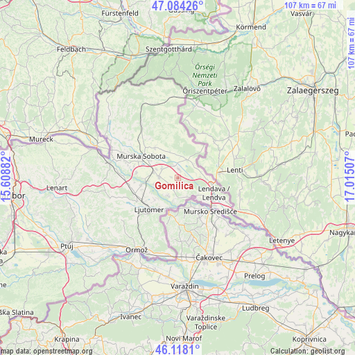
Gomilica GPS coordinates[2]
46° 36' 11.988" North, 16° 18' 42.984" East
| Map corner | latitude | longitude |
|---|---|---|
| Upper-left | 47.08426°, | 15.60882° |
| Center: | 46.60333°, | 16.31194° |
| Lower-right: | 46.1181°, | 17.01507° |
| Map W x H: | 107.4×107.4 km | = 66.7×66.7mi |
| max Lat: | 46.83694° ⇑9% North |
| Gomilica: | 46.60333° |
| min Lat: | ⇓91% South 45.47667° |
| min Long | Gomilica | max Long |
| 13.52639° | 16.31194° | 16.4975° |
| W 97.7%⇐ | ⇒2.3% E |
Elevation
Elevation of Gomilica is 168 m = 551 ft, and this is 157.6 m = 517 ft below average elevation for this country.
| Max E: |
1551 m = 5089 ft | 88.8% |
| Avg. | 325.6 m = 1068 ft | |
| Gomilica | 168 m = 551 ft | |
Min E: |
2 m = 7 ft | 11.2% |
See also: Slovenia elevation on elevation.city.
Geographical zone
Gomilica is located in North temperate zone (between Tropic of Cancer and the Arctic Circle). Distance of this North polar circle is 2219.4 km =1379.1 mi to North.| Distance of | km | miles | from Gomilica |
|---|---|---|---|
| North Pole | 4825.3 | 2998.3 | to North |
| Arctic Circle | 2219.4 | 1379.1 | to North |
| Tropic Cancer | 2575.9 | 1600.6 | to South |
| Equator | 5181.8 | 3219.8 | to South |


Nearby cities:
15 places around Gomilica: (largest is in red/bold)
• Beltinci
5.5 km =3.4 mi,  272°
272°
• Dobrovnik
6.2 km =3.9 mi,  30°
30°
• Gančani
5.7 km =3.5 mi,  304°
304°
• Gornja Bistrica
5.3 km =3.3 mi,  220°
220°
• Hotiza
7 km =4.3 mi,  148°
148°
• Lipa
1.9 km =1.2 mi,  282°
282°
• Melinci
6.6 km =4.1 mi,  240°
240°
• Nedelica
2.2 km =1.4 mi,  47°
47°
• Odranci
3 km =1.9 mi,  232°
232°
• Renkovci
3.8 km =2.4 mi,  349°
349°
• Trnje
1.8 km =1.1 mi,  188°
188°
• Turnišče
2.8 km =1.7 mi,  13°
13°
• Velika Polana
4.4 km =2.7 mi,  142°
142°
• Črenšovci
5.1 km =3.2 mi, 186°
• Žižki
4 km =2.5 mi,  176°
176°
Sources, notices
• [Note1] Compared only with cities in Slovenia existing in our database
• [Src1] Map data: © OpenStreetMap contributors (CC-BY-SA)
• [Src2] Other city data from geonames.org with taken over terms of usage.
• [Src3] Geographical zone / Annual Mean Temperature by Robert A. Rohde @ Wikipedia
