Rodica geodata
Rodica (Domžale) is a populated place; located in Slovenia in Europe/Ljubljana (GMT+2) time zone. With population of 857 people, there are 269 cities with bigger population in this country. Compared to other cities in Slovenia, 63.8% of cities are located further ↑North; 62.7% of cities are located further →East and 53.3% of cities have lower elevation than Rodica. Note1


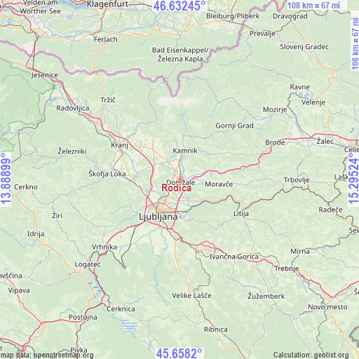
Rodica GPS coordinates[2]
46° 8' 50.928" North, 14° 35' 31.596" East
| Map corner | latitude | longitude |
|---|---|---|
| Upper-left | 46.63245°, | 13.88899° |
| Center: | 46.14748°, | 14.59211° |
| Lower-right: | 45.6582°, | 15.29524° |
| Map W x H: | 108.3×108.3 km | = 67.3×67.3mi |
| max Lat: | 46.83694° ⇑63.8% North |
| Rodica: | 46.14748° |
| min Lat: | ⇓36.2% South 45.47667° |
| min Long | Rodica | max Long |
| 13.52639° | 14.59211° | 16.4975° |
| W 37.3%⇐ | ⇒62.7% E |
Elevation
Elevation of Rodica is 306 m = 1004 ft, and this is 19.6 m = 64 ft below average elevation for this country.
| Max E: |
1551 m = 5089 ft | 46.7% |
| Avg. | 325.6 m = 1068 ft | |
| Rodica | 306 m = 1004 ft | |
Min E: |
2 m = 7 ft | 53.3% |
See also: Slovenia elevation on elevation.city.
Geographical zone
Rodica is located in North temperate zone (between Tropic of Cancer and the Arctic Circle). Distance of this North polar circle is 2270.1 km =1410.6 mi to North.| Distance of | km | miles | from Rodica |
|---|---|---|---|
| North Pole | 4875.9 | 3029.7 | to North |
| Arctic Circle | 2270.1 | 1410.6 | to North |
| Tropic Cancer | 2525.2 | 1569.1 | to South |
| Equator | 5131.1 | 3188.3 | to South |


Nearby cities:
15 places around Rodica: (largest is in red/bold)
• Depala Vas
1.7 km =1.1 mi,  203°
203°
• Dob
2.9 km =1.8 mi,  79°
79°
• Domžale
1.1 km =0.7 mi,  173°
173°
• Homec
4 km =2.5 mi,  8°
8°
• Ihan
3.7 km =2.3 mi,  144°
144°
• Loka pri Mengšu
2.1 km =1.3 mi,  277°
277°
• Mengeš
2.5 km =1.6 mi,  328°
328°
• Prelog
2.8 km =1.7 mi,  146°
146°
• Preserje pri Radomljah
2.4 km =1.5 mi, 8°
• Radomlje
3.3 km =2.1 mi,  28°
28°
• Spodnje Jarše
0.7 km =0.4 mi,  65°
65°
• Srednje Jarše
1.1 km =0.7 mi,  15°
15°
• Trzin
2.5 km =1.6 mi,  231°
231°
• Vir
1.3 km =0.8 mi,  61°
61°
• Zaboršt
2.1 km =1.3 mi,  129°
129°
Sources, notices
• [Note1] Compared only with cities in Slovenia existing in our database
• [Src1] Map data: © OpenStreetMap contributors (CC-BY-SA)
• [Src2] Other city data from geonames.org with taken over terms of usage.
• [Src3] Geographical zone / Annual Mean Temperature by Robert A. Rohde @ Wikipedia
