Port-aux-Français geodata
Port-aux-Français (Kerguelen) is a capital of a political entity; located in French Southern Territories in Indian/Kerguelen (GMT+5) time zone. With population of 45 people, there are 0 cities with bigger population in this country. Note1


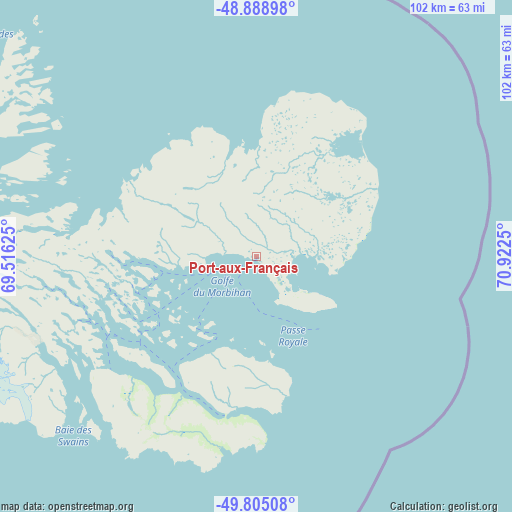
Port-aux-Français GPS coordinates[2]
49° 20' 56.976" South, 70° 13' 9.732" East
| Map corner | latitude | longitude |
|---|---|---|
| Upper-left | -48.88898°, | 69.51625° |
| Center: | -49.34916°, | 70.21937° |
| Lower-right: | -49.80508°, | 70.9225° |
| Map W x H: | 101.9×101.9 km | = 63.3×63.3mi |
Elevation
Elevation of Port-aux-Français is 5 m = 16 ft, and this is 0 m = 0 ft above average elevation for this country.
See also: French Southern Territories elevation on elevation.city.
Geographical zone
Port-aux-Français is located in South temperate zone (between Tropic of Capricorn and the Antarctic Circle). Distance of this South polar circle is 1914.1 km =1189.4 mi to South.| Distance of | km | miles | from Port-aux-Français |
|---|---|---|---|
| Equator | 5487.1 | 3409.5 | to North |
| Tropic Capricorn | 2881.2 | 1790.3 | to North |
| Antarctic Circle | 1914.1 | 1189.4 | to South |
| South Pole | 4519.9 | 2808.5 | to South |


Nearby cities:
0 places around Port-aux-Français: (largest is in red/bold)
There is no such city in our database.
Sources, notices
• [Note1] Compared only with cities in French Southern Territories existing in our database
• [Src1] Map data: © OpenStreetMap contributors (CC-BY-SA)
• [Src2] Other city data from geonames.org with taken over terms of usage.
• [Src3] Geographical zone / Annual Mean Temperature by Robert A. Rohde @ Wikipedia
