Peñal geodata
Peñal (Penal/Debe) is a seat of a first-order administrative division; located in Trinidad and Tobago in America/Port_of_Spain (GMT-4) time zone. With population of 12,281 people, there are 13 cities with bigger population in this country. Compared to other cities in Trinidad and Tobago, 95.5% of cities are located further ↑North; 59.1% of cities are located further →East and 90.9% of cities have higher elevation than Peñal. Note1


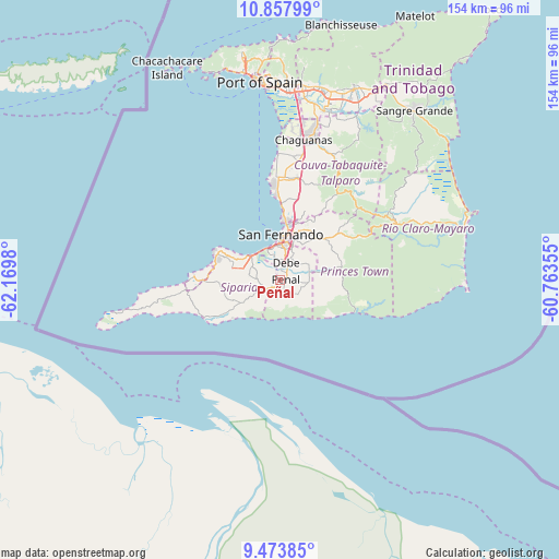
Peñal GPS coordinates[2]
10° 10' 0.012" North, 61° 28' 0.012" West
| Map corner | latitude | longitude |
|---|---|---|
| Upper-left | 10.85799°, | -62.1698° |
| Center: | 10.16667°, | -61.46667° |
| Lower-right: | 9.47385°, | -60.76355° |
| Map W x H: | 153.9×153.9 km | = 95.6×95.6mi |
| max Lat: | 11.18229° ⇑95.5% North |
| Peñal: | 10.16667° |
| min Lat: | ⇓4.5% South 10.14525° |
| min Long | Peñal | max Long |
| -61.68407° | -61.46667° | -60.73525° |
| W 40.9%⇐ | ⇒59.1% E |
Elevation
Elevation of Peñal is 8 m = 26 ft, and this is 28.9 m = 95 ft below average elevation for this country.
| Max E: |
100 m = 328 ft | 90.9% |
| Avg. | 36.9 m = 121 ft | |
| Peñal | 8 m = 26 ft | |
Min E: |
3 m = 10 ft | 9.1% |
See also: Trinidad and Tobago elevation on elevation.city.
Geographical zone
Peñal is located in North Torrid zone (between Equator and Tropic of Cancer). Distance of Equator is 1130.4 km =702.4 mi to South.| Distance of | km | miles | from Peñal |
|---|---|---|---|
| North Pole | 8876.6 | 5515.7 | to North |
| Arctic Circle | 6270.7 | 3896.4 | to North |
| Tropic Cancer | 1475.5 | 916.8 | to North |
| Equator | 1130.4 | 702.4 | to South |


Nearby cities:
15 places around Peñal: (largest is in red/bold)
• Arouca
53.4 km =33.2 mi,  15°
15°
• Chaguanas
39.3 km =24.4 mi,  7°
7°
• Couva
28.4 km =17.6 mi,  359°
359°
• Debe
4.9 km =3 mi, 18°
• Laventille
53.8 km =33.4 mi, 356°
• Marabella
15.7 km =9.8 mi, 8°
• Mon Repos
12.8 km =8 mi, 10°
• Paradise
55.2 km =34.3 mi, 11°
• Point Fortin
23.8 km =14.8 mi,  271°
271°
• Princes Town
15.7 km =9.8 mi,  41°
41°
• Rio Claro
35.4 km =22 mi,  64°
64°
• San Fernando
12.6 km =7.8 mi, 359°
• Siparia
5.1 km =3.2 mi,  241°
241°
• Tabaquite
30.8 km =19.1 mi, 36°
• Tunapuna
54.7 km =34 mi, 8°
Sources, notices
• [Note1] Compared only with cities in Trinidad and Tobago existing in our database
• [Src1] Map data: © OpenStreetMap contributors (CC-BY-SA)
• [Src2] Other city data from geonames.org with taken over terms of usage.
• [Src3] Geographical zone / Annual Mean Temperature by Robert A. Rohde @ Wikipedia
