Hoover geodata
Hoover (Alabama) is a populated place; located in United States in America/Chicago (GMT-5) time zone. With population of 84,848 people, there are 456 cities with bigger population in this country. Compared to other cities in United States, 83.6% of cities are located further ↑North; 50.7% of cities are located further ←West and 53.6% of cities have higher elevation than Hoover. Note1


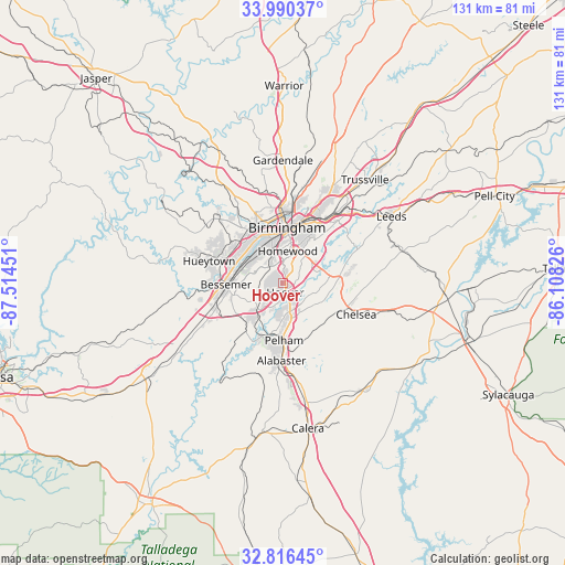
Hoover GPS coordinates[2]
33° 24' 19.404" North, 86° 48' 40.968" West
| Map corner | latitude | longitude |
|---|---|---|
| Upper-left | 33.99037°, | -87.51451° |
| Center: | 33.40539°, | -86.81138° |
| Lower-right: | 32.81645°, | -86.10826° |
| Map W x H: | 130.5×130.5 km | = 81.1×81.1mi |
| max Lat: | 71.29058° ⇑83.6% North |
| Hoover: | 33.40539° |
| min Lat: | ⇓16.4% South 19.06759° |
| min Long | Hoover | max Long |
| -171.73463° | -86.81138° | -66.98998° |
| W 50.7%⇐ | ⇒49.3% E |
Elevation
Elevation of Hoover is 185 m = 607 ft, and this is 109.8 m = 360 ft below average elevation for this country.
| Max E: |
3189 m = 10463 ft | 53.6% |
| Avg. | 294.8 m = 967 ft | |
| Hoover | 185 m = 607 ft | |
Min E: |
-60 m = -197 ft | 46.4% |
See also: Hoover elevation on elevation.city.
Geographical zone
Hoover is located in North temperate zone (between Tropic of Cancer and the Arctic Circle). Distance of this Northern Tropic circle is 1108.4 km =688.7 mi to South.| Distance of | km | miles | from Hoover |
|---|---|---|---|
| North Pole | 6292.7 | 3910.1 | to North |
| Arctic Circle | 3686.8 | 2290.9 | to North |
| Tropic Cancer | 1108.4 | 688.7 | to South |
| Equator | 3714.3 | 2308 | to South |


Nearby cities:
15 places around Hoover: (largest is in red/bold)
• Birmingham
12.8 km =8 mi,  3°
3°
• Brighton
13 km =8.1 mi,  284°
284°
• Brook Highland
13.2 km =8.2 mi,  75°
75°
• Cahaba Heights
9.8 km =6.1 mi,  48°
48°
• Fairfield
12.9 km =8 mi,  313°
313°
• Helena
12.5 km =7.8 mi,  193°
193°
• Hollywood
8 km =5 mi,  19°
19°
• Homewood
7.4 km =4.6 mi,  7°
7°
• Indian Springs Village
7.7 km =4.8 mi,  136°
136°
• Lake Purdy
12.5 km =7.8 mi, 77°
• Lipscomb
10.9 km =6.8 mi, 281°
• Meadowbrook
10.7 km =6.6 mi,  91°
91°
• Midfield
11 km =6.8 mi,  304°
304°
• Mountain Brook
12 km =7.5 mi,  27°
27°
• Vestavia Hills
5.3 km =3.3 mi, 24°
Sources, notices
• [Note1] Compared only with cities in United States existing in our database
• [Src1] Map data: © OpenStreetMap contributors (CC-BY-SA)
• [Src2] Other city data from geonames.org with taken over terms of usage.
• [Src3] Geographical zone / Annual Mean Temperature by Robert A. Rohde @ Wikipedia
