McAlmont geodata
McAlmont (Arkansas) is a populated place; located in United States in America/Chicago (GMT-5) time zone. With population of 1,873 people, there are 12301 cities with bigger population in this country. Compared to other cities in United States, 76.3% of cities are located further ↑North; 64.5% of cities are located further →East and 72.5% of cities have higher elevation than McAlmont. Note1


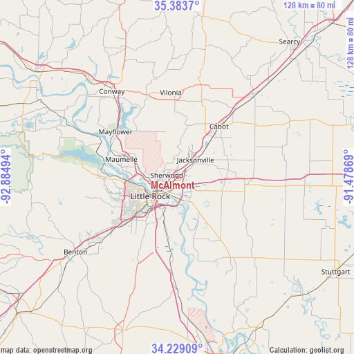
McAlmont GPS coordinates[2]
34° 48' 30.312" North, 92° 10' 54.516" West
| Map corner | latitude | longitude |
|---|---|---|
| Upper-left | 35.3837°, | -92.88494° |
| Center: | 34.80842°, | -92.18181° |
| Lower-right: | 34.22909°, | -91.47869° |
| Map W x H: | 128.4×128.4 km | = 79.8×79.8mi |
| max Lat: | 71.29058° ⇑76.3% North |
| McAlmont: | 34.80842° |
| min Lat: | ⇓23.7% South 19.06759° |
| min Long | McAlmont | max Long |
| -171.73463° | -92.18181° | -66.98998° |
| W 35.5%⇐ | ⇒64.5% E |
Elevation
Elevation of McAlmont is 86 m = 282 ft, and this is 208.8 m = 685 ft below average elevation for this country.
| Max E: |
3189 m = 10463 ft | 72.5% |
| Avg. | 294.8 m = 967 ft | |
| McAlmont | 86 m = 282 ft | |
Min E: |
-60 m = -197 ft | 27.5% |
See also: United States elevation on elevation.city.
Geographical zone
McAlmont is located in North temperate zone (between Tropic of Cancer and the Arctic Circle). Distance of this Northern Tropic circle is 1264.4 km =785.7 mi to South.| Distance of | km | miles | from McAlmont |
|---|---|---|---|
| North Pole | 6136.7 | 3813.2 | to North |
| Arctic Circle | 3530.8 | 2193.9 | to North |
| Tropic Cancer | 1264.4 | 785.7 | to South |
| Equator | 3870.3 | 2404.9 | to South |


Nearby cities:
15 places around McAlmont: (largest is in red/bold)
• Cabot
23.8 km =14.8 mi,  39°
39°
• Cammack Village
15.6 km =9.7 mi,  257°
257°
• College Station
11.7 km =7.3 mi,  197°
197°
• Gibson
9.8 km =6.1 mi,  329°
329°
• Gravel Ridge
6.7 km =4.2 mi,  353°
353°
• Jacksonville
9.2 km =5.7 mi,  45°
45°
• Landmark
25.3 km =15.7 mi,  209°
209°
• Little Rock
12 km =7.5 mi,  235°
235°
• Little Rock Air Force Base
9.5 km =5.9 mi,  12°
12°
• Lonoke
25.9 km =16.1 mi,  96°
96°
• Maumelle
21.3 km =13.2 mi,  287°
287°
• North Little Rock
8.9 km =5.5 mi, 240°
• Sherwood
4 km =2.5 mi,  280°
280°
• Sweet Home
14.6 km =9.1 mi, 202°
• Wrightsville
23.1 km =14.4 mi,  187°
187°
Sources, notices
• [Note1] Compared only with cities in United States existing in our database
• [Src1] Map data: © OpenStreetMap contributors (CC-BY-SA)
• [Src2] Other city data from geonames.org with taken over terms of usage.
• [Src3] Geographical zone / Annual Mean Temperature by Robert A. Rohde @ Wikipedia
