North Star geodata
North Star (Delaware) is a populated place; located in United States in America/New_York (GMT-4) time zone. With population of 7,980 people, there are 5289 cities with bigger population in this country. Compared to other cities in United States, 51.2% of cities are located further ↓South; 84.9% of cities are located further ←West and 68% of cities have higher elevation than North Star. Note1


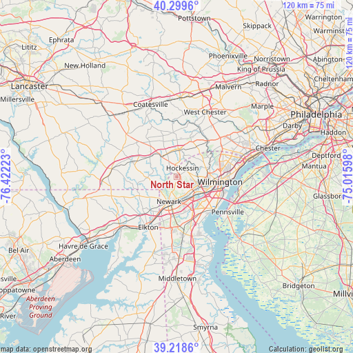
North Star GPS coordinates[2]
39° 45' 40.392" North, 75° 43' 8.76" West
| Map corner | latitude | longitude |
|---|---|---|
| Upper-left | 40.2996°, | -76.42223° |
| Center: | 39.76122°, | -75.7191° |
| Lower-right: | 39.2186°, | -75.01598° |
| Map W x H: | 120.2×120.2 km | = 74.7×74.7mi |
| max Lat: | 71.29058° ⇑48.8% North |
| North Star: | 39.76122° |
| min Lat: | ⇓51.2% South 19.06759° |
| min Long | North Star | max Long |
| -171.73463° | -75.7191° | -66.98998° |
| W 84.9%⇐ | ⇒15.1% E |
Elevation
Elevation of North Star is 112 m = 367 ft, and this is 182.8 m = 600 ft below average elevation for this country.
| Max E: |
3189 m = 10463 ft | 68% |
| Avg. | 294.8 m = 967 ft | |
| North Star | 112 m = 367 ft | |
Min E: |
-60 m = -197 ft | 32% |
See also: United States elevation on elevation.city.
Geographical zone
North Star is located in North temperate zone (between Tropic of Cancer and the Arctic Circle). Distance of this Northern Tropic circle is 1815.1 km =1127.9 mi to South.| Distance of | km | miles | from North Star |
|---|---|---|---|
| North Pole | 5586 | 3471 | to North |
| Arctic Circle | 2980.1 | 1851.7 | to North |
| Tropic Cancer | 1815.1 | 1127.9 | to South |
| Equator | 4421 | 2747.1 | to South |


Nearby cities:
15 places around North Star: (largest is in red/bold)
• Avondale
8.8 km =5.5 mi,  321°
321°
• Brookside
10.5 km =6.5 mi,  183°
183°
• Elsmere
10.6 km =6.6 mi,  103°
103°
• Greenville
10.5 km =6.5 mi,  79°
79°
• Hockessin
3.5 km =2.2 mi,  33°
33°
• Kennett Square
9.5 km =5.9 mi,  3°
3°
• Newark
9 km =5.6 mi,  196°
196°
• Newport
10.8 km =6.7 mi,  119°
119°
• Pike Creek
3.6 km =2.2 mi,  159°
159°
• Pike Creek Valley
3.3 km =2.1 mi,  147°
147°
• Toughkenamon
8.5 km =5.3 mi,  337°
337°
• Upland
14.7 km =9.1 mi, 341°
• West Grove
11.5 km =7.1 mi,  306°
306°
• Wilmington
14.8 km =9.2 mi, 96°
• Wilmington Manor
14.2 km =8.8 mi,  125°
125°
Sources, notices
• [Note1] Compared only with cities in United States existing in our database
• [Src1] Map data: © OpenStreetMap contributors (CC-BY-SA)
• [Src2] Other city data from geonames.org with taken over terms of usage.
• [Src3] Geographical zone / Annual Mean Temperature by Robert A. Rohde @ Wikipedia
