Allapattah geodata
Allapattah (Florida) is a populated place; located in United States in America/New_York (GMT-4) time zone. With population of 54,289 people, there are 857 cities with bigger population in this country. Compared to other cities in United States, 99.1% of cities are located further ↑North; 72.1% of cities are located further ←West and 93% of cities have higher elevation than Allapattah. Note1


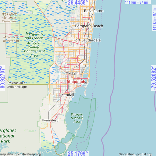
Allapattah GPS coordinates[2]
25° 48' 52.344" North, 80° 13' 26.184" West
| Map corner | latitude | longitude |
|---|---|---|
| Upper-left | 26.4458°, | -80.92707° |
| Center: | 25.81454°, | -80.22394° |
| Lower-right: | 25.1799°, | -79.52082° |
| Map W x H: | 140.8×140.8 km | = 87.5×87.5mi |
| max Lat: | 71.29058° ⇑99.1% North |
| Allapattah: | 25.81454° |
| min Lat: | ⇓0.9% South 19.06759° |
| min Long | Allapattah | max Long |
| -171.73463° | -80.22394° | -66.98998° |
| W 72.1%⇐ | ⇒27.9% E |
Elevation
Elevation of Allapattah is 11 m = 36 ft, and this is 283.8 m = 931 ft below average elevation for this country.
| Max E: |
3189 m = 10463 ft | 93% |
| Avg. | 294.8 m = 967 ft | |
| Allapattah | 11 m = 36 ft | |
Min E: |
-60 m = -197 ft | 7% |
See also: Allapattah elevation on elevation.city.
Geographical zone
Allapattah is located in North temperate zone (between Tropic of Cancer and the Arctic Circle). Distance of this Northern Tropic circle is 264.4 km =164.3 mi to South.| Distance of | km | miles | from Allapattah |
|---|---|---|---|
| North Pole | 7136.8 | 4434.6 | to North |
| Arctic Circle | 4530.9 | 2815.4 | to North |
| Tropic Cancer | 264.4 | 164.3 | to South |
| Equator | 2870.3 | 1783.5 | to South |


Nearby cities:
15 places around Allapattah: (largest is in red/bold)
• Biscayne Park
8.7 km =5.4 mi,  29°
29°
• Brownsville
1.9 km =1.2 mi,  294°
294°
• El Portal
5.5 km =3.4 mi, 34°
• Gladeview
3 km =1.9 mi,  336°
336°
• Hialeah
7.2 km =4.5 mi,  311°
311°
• Miami
5.4 km =3.4 mi,  145°
145°
• Miami Shores
6.2 km =3.9 mi, 29°
• Miami Springs
6.6 km =4.1 mi,  277°
277°
• North Bay Village
7.8 km =4.8 mi,  63°
63°
• North Miami
9.2 km =5.7 mi,  23°
23°
• Pinewood
6.1 km =3.8 mi,  6°
6°
• Virginia Gardens
7.9 km =4.9 mi,  266°
266°
• West Little River
4.9 km =3 mi, 344°
• West Miami
9.2 km =5.7 mi,  231°
231°
• Westview
7.7 km =4.8 mi,  346°
346°
Sources, notices
• [Note1] Compared only with cities in United States existing in our database
• [Src1] Map data: © OpenStreetMap contributors (CC-BY-SA)
• [Src2] Other city data from geonames.org with taken over terms of usage.
• [Src3] Geographical zone / Annual Mean Temperature by Robert A. Rohde @ Wikipedia
