Davie geodata
Davie (Florida) is a populated place; located in United States in America/New_York (GMT-4) time zone. With population of 100,882 people, there are 345 cities with bigger population in this country. Compared to other cities in United States, 98.8% of cities are located further ↑North; 72% of cities are located further ←West and 93% of cities have higher elevation than Davie. Note1


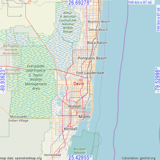
Davie GPS coordinates[2]
26° 3' 46.332" North, 80° 13' 59.16" West
| Map corner | latitude | longitude |
|---|---|---|
| Upper-left | 26.69278°, | -80.93623° |
| Center: | 26.06287°, | -80.2331° |
| Lower-right: | 25.42955°, | -79.52998° |
| Map W x H: | 140.5×140.5 km | = 87.3×87.3mi |
| max Lat: | 71.29058° ⇑98.8% North |
| Davie: | 26.06287° |
| min Lat: | ⇓1.2% South 19.06759° |
| min Long | Davie | max Long |
| -171.73463° | -80.2331° | -66.98998° |
| W 72%⇐ | ⇒28% E |
Elevation
Elevation of Davie is 11 m = 36 ft, and this is 283.8 m = 931 ft below average elevation for this country.
| Max E: |
3189 m = 10463 ft | 93% |
| Avg. | 294.8 m = 967 ft | |
| Davie | 11 m = 36 ft | |
Min E: |
-60 m = -197 ft | 7% |
See also: Davie elevation on elevation.city.
Geographical zone
Davie is located in North temperate zone (between Tropic of Cancer and the Arctic Circle). Distance of this Northern Tropic circle is 292 km =181.4 mi to South.| Distance of | km | miles | from Davie |
|---|---|---|---|
| North Pole | 7109.1 | 4417.4 | to North |
| Arctic Circle | 4503.3 | 2798.2 | to North |
| Tropic Cancer | 292 | 181.4 | to South |
| Equator | 2897.9 | 1800.7 | to South |


Nearby cities:
15 places around Davie: (largest is in red/bold)
• Boulevard Gardens
8.6 km =5.3 mi,  38°
38°
• Broadview Park
4.8 km =3 mi,  30°
30°
• Broward Estates
8 km =5 mi, 29°
• Carver Ranches
9.2 km =5.7 mi,  153°
153°
• Cooper City
3.9 km =2.4 mi,  260°
260°
• Dania Beach
9 km =5.6 mi,  97°
97°
• Lauderhill
8.8 km =5.5 mi,  12°
12°
• Melrose Park
6.9 km =4.3 mi, 35°
• Miramar
8.4 km =5.2 mi,  179°
179°
• Pembroke Pines
6.7 km =4.2 mi,  172°
172°
• Pine Island Ridge
5.4 km =3.4 mi,  311°
311°
• Plantation
7.9 km =4.9 mi,  0°
0°
• Washington Park
9.3 km =5.8 mi, 33°
• West Hollywood
6.8 km =4.2 mi,  133°
133°
• West Park
9.4 km =5.8 mi,  158°
158°
Sources, notices
• [Note1] Compared only with cities in United States existing in our database
• [Src1] Map data: © OpenStreetMap contributors (CC-BY-SA)
• [Src2] Other city data from geonames.org with taken over terms of usage.
• [Src3] Geographical zone / Annual Mean Temperature by Robert A. Rohde @ Wikipedia
