Fort Myers Beach geodata
Fort Myers Beach (Florida) is a populated place; located in United States in America/New_York (GMT-4) time zone. With population of 6,983 people, there are 5824 cities with bigger population in this country. Compared to other cities in United States, 98.1% of cities are located further ↑North; 65.7% of cities are located further ←West and 98.1% of cities have higher elevation than Fort Myers Beach. Note1


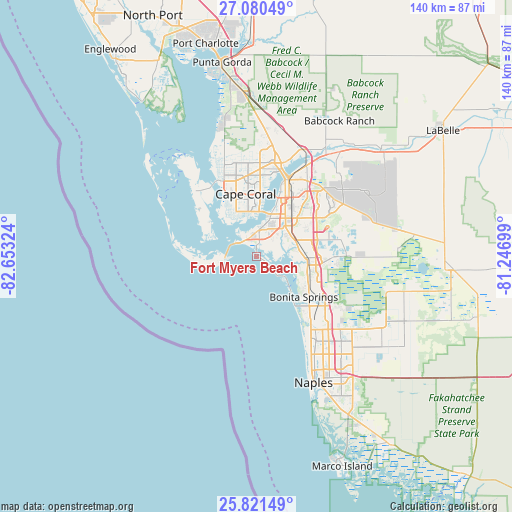
Fort Myers Beach GPS coordinates[2]
26° 27' 9.756" North, 81° 57' 0.396" West
| Map corner | latitude | longitude |
|---|---|---|
| Upper-left | 27.08049°, | -82.65324° |
| Center: | 26.45271°, | -81.95011° |
| Lower-right: | 25.82149°, | -81.24699° |
| Map W x H: | 140×140 km | = 87×87mi |
| max Lat: | 71.29058° ⇑98.1% North |
| Fort Myers Beach: | 26.45271° |
| min Lat: | ⇓1.9% South 19.06759° |
| min Long | Fort Myers Beac | max Long |
| -171.73463° | -81.95011° | -66.98998° |
| W 65.7%⇐ | ⇒34.3% E |
Elevation
Elevation of Fort Myers Beach is 5 m = 16 ft, and this is 289.8 m = 951 ft below average elevation for this country.
| Max E: |
3189 m = 10463 ft | 98.1% |
| Avg. | 294.8 m = 967 ft | |
| Fort Myers Beach | 5 m = 16 ft | |
Min E: |
-60 m = -197 ft | 1.9% |
See also: United States elevation on elevation.city.
Geographical zone
Fort Myers Beach is located in North temperate zone (between Tropic of Cancer and the Arctic Circle). Distance of this Northern Tropic circle is 335.3 km =208.3 mi to South.| Distance of | km | miles | from Fort Myers Beach |
|---|---|---|---|
| North Pole | 7065.8 | 4390.5 | to North |
| Arctic Circle | 4459.9 | 2771.3 | to North |
| Tropic Cancer | 335.3 | 208.3 | to South |
| Equator | 2941.3 | 1827.6 | to South |


Nearby cities:
15 places around Fort Myers Beach: (largest is in red/bold)
• Cape Coral
12.2 km =7.6 mi,  0°
0°
• Cypress Lake
10.8 km =6.7 mi,  28°
28°
• Estero
14.4 km =8.9 mi,  96°
96°
• Harlem Heights
7.4 km =4.6 mi,  17°
17°
• Iona
7.6 km =4.7 mi,  349°
349°
• McGregor
12.5 km =7.8 mi, 16°
• Page Park
16.6 km =10.3 mi, 31°
• Pine Manor
15.2 km =9.4 mi, 28°
• Punta Rassa
7.3 km =4.5 mi,  302°
302°
• Saint James City
13.7 km =8.5 mi,  291°
291°
• San Carlos Park
14.9 km =9.3 mi,  83°
83°
• Sanibel
7.2 km =4.5 mi,  266°
266°
• Three Oaks
15.7 km =9.8 mi, 82°
• Villas
13.5 km =8.4 mi,  36°
36°
• Whiskey Creek
14.6 km =9.1 mi, 24°
Sources, notices
• [Note1] Compared only with cities in United States existing in our database
• [Src1] Map data: © OpenStreetMap contributors (CC-BY-SA)
• [Src2] Other city data from geonames.org with taken over terms of usage.
• [Src3] Geographical zone / Annual Mean Temperature by Robert A. Rohde @ Wikipedia
