Gulf Stream geodata
Gulf Stream (Florida) is a populated place; located in United States in America/New_York (GMT-4) time zone. With population of 836 people, there are 17486 cities with bigger population in this country. Compared to other cities in United States, 98% of cities are located further ↑North; 73.1% of cities are located further ←West and 96.6% of cities have higher elevation than Gulf Stream. Note1


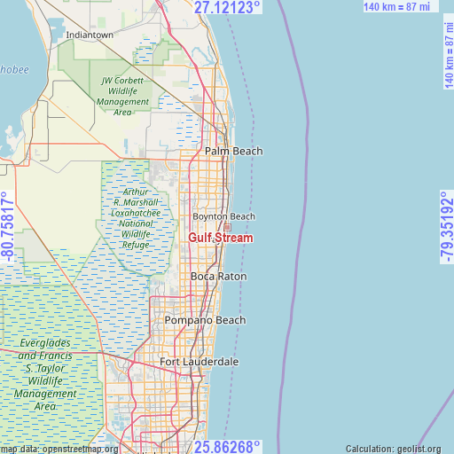
Gulf Stream GPS coordinates[2]
26° 29' 37.248" North, 80° 3' 18.144" West
| Map corner | latitude | longitude |
|---|---|---|
| Upper-left | 27.12123°, | -80.75817° |
| Center: | 26.49368°, | -80.05504° |
| Lower-right: | 25.86268°, | -79.35192° |
| Map W x H: | 139.9×139.9 km | = 86.9×86.9mi |
| max Lat: | 71.29058° ⇑98% North |
| Gulf Stream: | 26.49368° |
| min Lat: | ⇓2% South 19.06759° |
| min Long | Gulf Stream | max Long |
| -171.73463° | -80.05504° | -66.98998° |
| W 73.1%⇐ | ⇒26.9% E |
Elevation
Elevation of Gulf Stream is 7 m = 23 ft, and this is 287.8 m = 944 ft below average elevation for this country.
| Max E: |
3189 m = 10463 ft | 96.6% |
| Avg. | 294.8 m = 967 ft | |
| Gulf Stream | 7 m = 23 ft | |
Min E: |
-60 m = -197 ft | 3.4% |
See also: United States elevation on elevation.city.
Geographical zone
Gulf Stream is located in North temperate zone (between Tropic of Cancer and the Arctic Circle). Distance of this Northern Tropic circle is 339.9 km =211.2 mi to South.| Distance of | km | miles | from Gulf Stream |
|---|---|---|---|
| North Pole | 7061.2 | 4387.6 | to North |
| Arctic Circle | 4455.4 | 2768.5 | to North |
| Tropic Cancer | 339.9 | 211.2 | to South |
| Equator | 2945.8 | 1830.4 | to South |


Nearby cities:
15 places around Gulf Stream: (largest is in red/bold)
• Aberdeen
11.3 km =7 mi,  304°
304°
• Atlantis
11.7 km =7.3 mi,  337°
337°
• Boynton Beach
3.7 km =2.3 mi, 342°
• Briny Breezes
1.7 km =1.1 mi,  14°
14°
• Delray Beach
4 km =2.5 mi,  206°
206°
• Highland Beach
10.5 km =6.5 mi,  185°
185°
• Hypoluxo
8.1 km =5 mi,  1°
1°
• Kings Point
10 km =6.2 mi,  237°
237°
• Lake Worth
13.8 km =8.6 mi,  352°
352°
• Lake Worth Corridor
14.4 km =8.9 mi, 341°
• Lantana
10.4 km =6.5 mi, 1°
• Ocean Ridge
3.8 km =2.4 mi, 10°
• Seminole Manor
11 km =6.8 mi, 335°
• South Palm Beach
10.7 km =6.6 mi, 8°
• Villages of Oriole
10.3 km =6.4 mi,  250°
250°
Sources, notices
• [Note1] Compared only with cities in United States existing in our database
• [Src1] Map data: © OpenStreetMap contributors (CC-BY-SA)
• [Src2] Other city data from geonames.org with taken over terms of usage.
• [Src3] Geographical zone / Annual Mean Temperature by Robert A. Rohde @ Wikipedia
