Howey-in-the-Hills geodata
Howey-in-the-Hills (Florida) is a populated place; located in United States in America/New_York (GMT-4) time zone. With population of 1,098 people, there are 15686 cities with bigger population in this country. Compared to other cities in United States, 95.6% of cities are located further ↑North; 66.4% of cities are located further ←West and 81.1% of cities have higher elevation than Howey-in-the-Hills. Note1


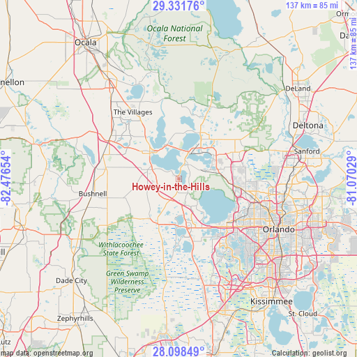
Howey-in-the-Hills GPS coordinates[2]
28° 43' 0.984" North, 81° 46' 24.276" West
| Map corner | latitude | longitude |
|---|---|---|
| Upper-left | 29.33176°, | -82.47654° |
| Center: | 28.71694°, | -81.77341° |
| Lower-right: | 28.09849°, | -81.07029° |
| Map W x H: | 137.1×137.1 km | = 85.2×85.2mi |
| max Lat: | 71.29058° ⇑95.6% North |
| Howey-in-the-Hills: | 28.71694° |
| min Lat: | ⇓4.4% South 19.06759° |
| min Long | Howey-in-the-Hi | max Long |
| -171.73463° | -81.77341° | -66.98998° |
| W 66.4%⇐ | ⇒33.6% E |
Elevation
Elevation of Howey-in-the-Hills is 42 m = 138 ft, and this is 252.8 m = 829 ft below average elevation for this country.
| Max E: |
3189 m = 10463 ft | 81.1% |
| Avg. | 294.8 m = 967 ft | |
| Howey-in-the-Hills | 42 m = 138 ft | |
Min E: |
-60 m = -197 ft | 18.9% |
See also: United States elevation on elevation.city.
Geographical zone
Howey-in-the-Hills is located in North temperate zone (between Tropic of Cancer and the Arctic Circle). Distance of this Northern Tropic circle is 587.1 km =364.8 mi to South.| Distance of | km | miles | from Howey-in-the-Hills |
|---|---|---|---|
| North Pole | 6814 | 4234 | to North |
| Arctic Circle | 4208.1 | 2614.8 | to North |
| Tropic Cancer | 587.1 | 364.8 | to South |
| Equator | 3193 | 1984 | to South |


Nearby cities:
15 places around Howey-in-the-Hills: (largest is in red/bold)
• Astatula
4 km =2.5 mi,  101°
101°
• Clermont
18.6 km =11.6 mi,  179°
179°
• Eustis
17.4 km =10.8 mi,  29°
29°
• Groveland
19.2 km =11.9 mi,  203°
203°
• Hawthorne
10.7 km =6.6 mi,  297°
297°
• Leesburg
14.6 km =9.1 mi,  315°
315°
• Mascotte
19 km =11.8 mi,  215°
215°
• Minneola
16.1 km =10 mi,  170°
170°
• Montverde
16.2 km =10.1 mi,  143°
143°
• Mount Dora
15.8 km =9.8 mi,  52°
52°
• Silver Lake
14.1 km =8.8 mi,  350°
350°
• Tangerine
14.9 km =9.3 mi,  69°
69°
• Tavares
10.8 km =6.7 mi, 25°
• Yalaha
4.2 km =2.6 mi, 304°
• Zellwood
16.9 km =10.5 mi,  84°
84°
Sources, notices
• [Note1] Compared only with cities in United States existing in our database
• [Src1] Map data: © OpenStreetMap contributors (CC-BY-SA)
• [Src2] Other city data from geonames.org with taken over terms of usage.
• [Src3] Geographical zone / Annual Mean Temperature by Robert A. Rohde @ Wikipedia
