Juno Beach geodata
Juno Beach (Florida) is a populated place; located in United States in America/New_York (GMT-4) time zone. With population of 3,474 people, there are 8879 cities with bigger population in this country. Compared to other cities in United States, 97.7% of cities are located further ↑North; 73.1% of cities are located further ←West and 91% of cities have higher elevation than Juno Beach. Note1


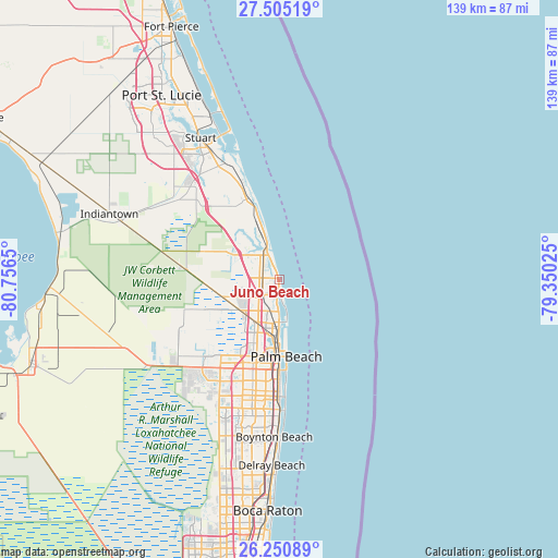
Juno Beach GPS coordinates[2]
26° 52' 47.208" North, 80° 3' 12.132" West
| Map corner | latitude | longitude |
|---|---|---|
| Upper-left | 27.50519°, | -80.7565° |
| Center: | 26.87978°, | -80.05337° |
| Lower-right: | 26.25089°, | -79.35025° |
| Map W x H: | 139.5×139.5 km | = 86.7×86.7mi |
| max Lat: | 71.29058° ⇑97.7% North |
| Juno Beach: | 26.87978° |
| min Lat: | ⇓2.3% South 19.06759° |
| min Long | Juno Beach | max Long |
| -171.73463° | -80.05337° | -66.98998° |
| W 73.1%⇐ | ⇒26.9% E |
Elevation
Elevation of Juno Beach is 14 m = 46 ft, and this is 280.8 m = 921 ft below average elevation for this country.
| Max E: |
3189 m = 10463 ft | 91% |
| Avg. | 294.8 m = 967 ft | |
| Juno Beach | 14 m = 46 ft | |
Min E: |
-60 m = -197 ft | 9% |
See also: United States elevation on elevation.city.
Geographical zone
Juno Beach is located in North temperate zone (between Tropic of Cancer and the Arctic Circle). Distance of this Northern Tropic circle is 382.8 km =237.9 mi to South.| Distance of | km | miles | from Juno Beach |
|---|---|---|---|
| North Pole | 7018.3 | 4361 | to North |
| Arctic Circle | 4412.4 | 2741.7 | to North |
| Tropic Cancer | 382.8 | 237.9 | to South |
| Equator | 2988.8 | 1857.2 | to South |


Nearby cities:
15 places around Juno Beach: (largest is in red/bold)
• Juno Ridge
3.6 km =2.2 mi,  194°
194°
• Jupiter
7.3 km =4.5 mi,  326°
326°
• Jupiter Island
17.5 km =10.9 mi,  344°
344°
• Lake Park
8.9 km =5.5 mi, 188°
• Limestone Creek
11.2 km =7 mi,  308°
308°
• Mangonia Park
13.4 km =8.3 mi, 188°
• North Palm Beach
7.5 km =4.7 mi,  202°
202°
• Palm Beach
19.4 km =12.1 mi,  175°
175°
• Palm Beach Gardens
10.5 km =6.5 mi,  233°
233°
• Palm Beach Shores
11.4 km =7.1 mi,  171°
171°
• Riviera Beach
11.6 km =7.2 mi, 182°
• Schall Circle
19.3 km =12 mi, 198°
• Tequesta
12.3 km =7.6 mi,  322°
322°
• West Gate
20.2 km =12.6 mi, 192°
• West Palm Beach
18.3 km =11.4 mi, 180°
Sources, notices
• [Note1] Compared only with cities in United States existing in our database
• [Src1] Map data: © OpenStreetMap contributors (CC-BY-SA)
• [Src2] Other city data from geonames.org with taken over terms of usage.
• [Src3] Geographical zone / Annual Mean Temperature by Robert A. Rohde @ Wikipedia
